Research
2023-#4
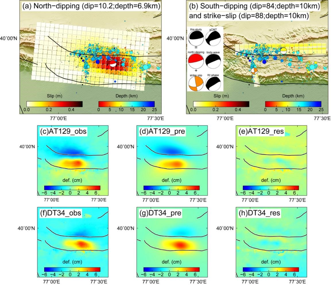
On 14 August 2021, an Mw7.2 earthquake struck Nippes, Haiti, 11 years after the devastating 2010 Mw7.0 Port-au-Prince earthquake. This earthquake occurred in a remote region where the structure at the depth of the main boundary Enriquillo Plantain Garden Fault (EPGF) is less known. Using SAR imagery, we retrieve the coseismic and early post-seismic deformation of the 2021 Haiti earthquake to constrain its fault geometry and slip distribution. Our model shows that the 2021 earthquake ruptured the high-angle Ravine du Sud fault and a bend fault ~64° dipping to the north at depth. While there is a possibility that the EPGF in the region is sub-vertical and unruptured, we propose an alternative mechanism that suggests the EPGF is ruptured at deep forming a nonplanar dipping geometry based on the analysis of geomorphic features, topography, and relocated aftershocks. East of the epicenter, we document a 25-km section along the EPGF that crept for ~15 days. This distribution of aseismic slip using stacked deformation indicates that only a small fraction of the accumulated strain near the surface was released during the earthquake, suggesting a high potential for seismic hazard in the region along the EPGF from the ruptured segment to the east, before reaching the 2010 rupture.
2021年8月14日,海地Nippes地区发生了Mw7.2级地震,此次地震距离灾害性的2010年Mw7.0级太子港地震已经过去了11年。这次地震发生在一个偏远地区,对于该区域的主要断层Enriquillo Plantain Garden Fault(EPGF) 深处的几何结构知之甚少。这里,我们利用合成孔径雷达(SAR)图像获取了2021年海地地震的同震和早期震后形变量测,以了解发震断层的几何形状和滑动分布。我们的模型显示,这次地震破裂了高角度的Ravine du Sud Fault和深处北倾约64°的弯曲断层。尽管该地区的EPGF有可能是垂直且未破裂的,但我们提出了一种替代机制。根据地貌特征、地形和余震的重新定位分析,我们认为2021年地震仅在深处北倾断层破裂,揭示了EPGF非平面倾斜的几何形状。在震中东侧,我们记录到了EPGF沿着25公里的区段,在震后约15天内发生了震后蠕滑。通过对干涉图叠加方法后的形变反演的到的非地震滑动的分布表明只有地表附近的应变的一小部分在地震期间释放。这表明EPGF地区从东侧的破裂段到2010年的破裂段之间仍然存在高地震危险性。
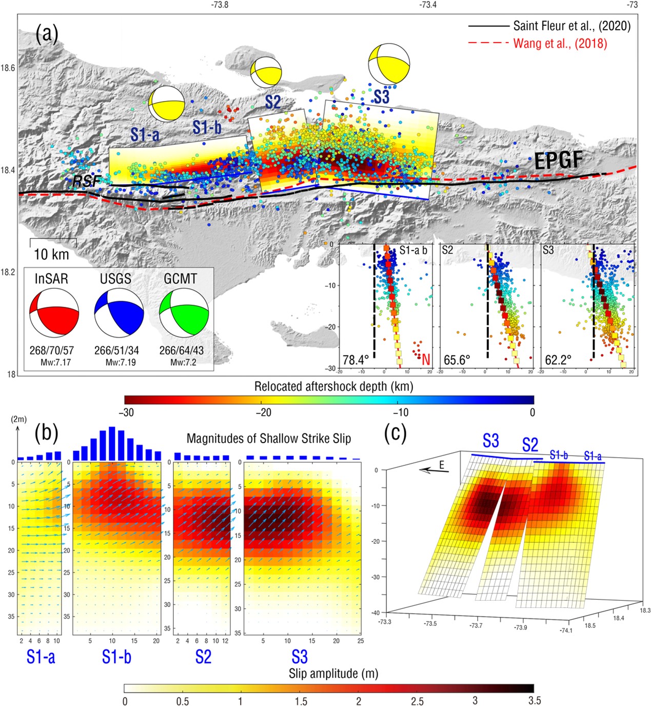
Fault geometry and slip distribution of the 2021 Haiti earthquake. (a) map view of the slip distribution with focal mechanisms from this study and different institutes. Blue lines represent surficial traces of the fault planes. Yellow beachballs indicate the focal mechanism of each segment. The inset shows the relocated aftershocks (Douilly et al., 2022) of each segment in cross-sections. The colored dots represent aftershocks. (b) Depth profiles of slip distribution. Arrows represent the slip direction. Blue bars on the top indicate the mean strike-slip motion at shallow (0-4 km) crust. (c) Three-dimensional view of the proposed slip-distribution model.
2021年海地地震的断层几何和滑动分布。(a) 发震断层滑移分布平面图,蓝色线表示断层面的地表痕迹,黄色沙滩球代表每个断层段的震源机制。插图显示了每个断层段的余震在剖面图中的重定位,彩色点代表余震。(b) 断层滑动分布的深度剖面图。箭头表示滑动方向。顶部的蓝色条表示浅层(0-4公里)地壳的平均走滑运动。(c) 提出的滑动分布模型的三维视图。
2023-#3
High-resolution interseismic strain mapping is important for studying faulting behavior and for assessing seismic hazards. Interferometric Synthetic Aperture Radar has been widely applied to measure interseismic deformation along active strike-slip faults. However, phase unwrapping errors and over-smoothing effects limit its ability to map the extremely-high strain due to shallow creep. Here, without the involvement of ground-based measurement, we perform phase-gradient stacking on wrapped Sentinel-1 interferograms to directly map the shear strain rates along the North Anatolian Fault (NAF) with unprecedented resolution. The derived high-resolution strain-rate map reveals five strain-concentrated segments on the NAF, implying shallow creeps. We find that their spatial distribution coincides with the lower coseismic slip of previous earthquakes that occurred since 1939. The proposed method can be applied to other less-studied strike-slip faults to distinguish segments with shallow creep and strong coupling, and thus to better quantify the shallow strain budget and its associated seismic hazards. 高分辨率震间应变绘制对于研究断层行为和评估地震灾害非常重要。干涉合成孔径雷达(InSAR)已被广泛应用于测量活跃走滑断层的震间变形。然而,相位解缠误差和过度平滑效应限制了其绘制浅层蠕滑引起的高应变的能力。这里,我们在不涉及地面测量的情况下,对缠绕的哨兵1 号干涉图进行相位梯度叠加,以前所未有的分辨率直接绘制出北安纳托利亚断层(NAF)沿线的剪切应变率。得出的高分辨率应变率地图揭示了NAF上的五个高应变集中段,意味着正在发生浅层蠕滑。我们发现,高应变率的空间分布与 1939 年以来发生的前几次地震的较低同震滑移相吻合。所提出的方法可应用于其他研究较少的走滑断层,以区分浅蠕滑和强耦合段,从而更好地量化浅层应变分布及其相关的地震危害。
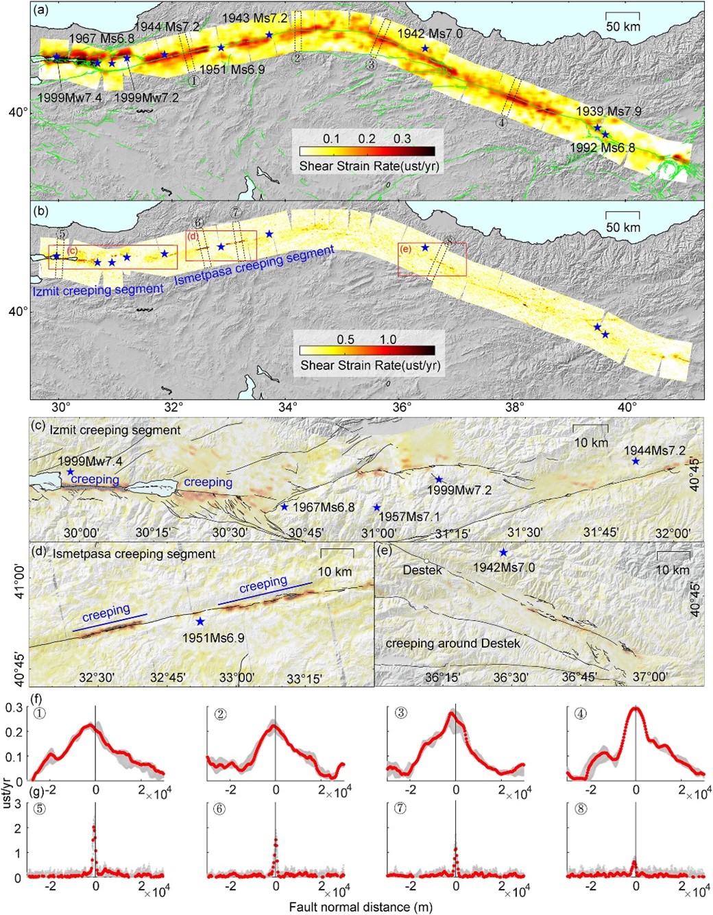
Shear strain rates along the NAF. The green line indicates the fault trace (Emre et al., 2013). Blue stars represent the locations of large earthquakes along the NAF since 1900. (a) and (b) Shear strain rates with 3 × 10 km2 and 2 × 2 km2 filter windows, respectively. Red rectangles in (b) indicate possible creeping segments with enlarged views of (c) Izmit creeping segment and east of it, (d) Ismetpasa creeping segment and (e) east of Destek. (f) and (g) The shear strain rate profiles (1) to (8) in (a) and (b). The solid line represents the position of the fault trace.
高分辨率震间应变绘制对于研究断层行为和评估地震灾害非常重要。干涉合成孔径雷达(InSAR)已被广泛应用于测量活跃走滑断层的震间变形。然而,相位解缠误差和过度平滑效应限制了其绘制浅层蠕滑引起的高应变的能力。这里,我们在不涉及地面测量的情况下,对缠绕的哨兵1 号干涉图进行相位梯度叠加,以前所未有的分辨率直接绘制出北安纳托利亚断层(NAF)沿线的剪切应变率。得出的高分辨率应变率地图揭示了NAF上的五个高应变集中段,意味着正在发生浅层蠕滑。我们发现,高应变率的空间分布与 1939 年以来发生的前几次地震的较低同震滑移相吻合。所提出的方法可应用于其他研究较少的走滑断层,以区分浅蠕滑和强耦合段,从而更好地量化浅层应变分布及其相关的地震危害。
2023-#2
In mountainous areas, landslides induced by destructive earthquakes are one of the main causes of human casualties, which is an important link in the chain of earthquake hazards. Earthquake-triggered landslides are mainly controlled by three factors, namely seismic property, topography, and geology. Many studies have been conducted on these controlling factors of earthquake-triggered landslides. However, little is known about the effect of coseismic displacement on the distribution of landslides under different slope aspects and slope angles, hindering our understanding of the mechanism of inducing landslides by the combination of surface displacement and slope geometry at the local scale and leading to controversial opinions about the abnormal number of earthquake-triggered landslides in several cases. Here, we took the 2008 Wenchuan Mw7.9 earthquake in China, the 2015 Gorkha Mw7.8 earthquake in Nepal, and the 2016 Kaikōura Mw7.8 earthquake in New Zealand as examples to investigate the relationship between the distribution of large earthquake-triggered landslides and the three-dimensional (3D) coseismic displacement field. We divided the landslide-prone area around the epicenter into regular grids and calculated the 3D coseismic displacement in each grid according to the radar satellite images and slip distribution model. Then, the 3D coseismic displacement was projected to two coordinate systems related to the slope where the landslides were located for statistical analysis. We determined that the surface uplift perpendicular to the slope is more likely to induce landslides, particularly when combined with large slope angles. Meanwhile, the number of landslides will be significantly reduced where the subsidence occurs. Regardless of uplift or subsidence, landslides are more likely to occur when the direction of coseismic horizontal displacement is far from the slope. The larger the slope angles are, the greater the effects of horizontal displacement and slope aspect. A dominant slope aspect also exists for earthquake-triggered landslides, which is different from the mean slope aspect calculated from the background topography. This dominant aspect angle is related to the focal mechanism and striking angle of surface rupture. These results indicate that we can simulate the 3D coseismic displacement field from known fault location and earthquake mechanism and combine the topographic data for landslide risk assessment in earthquake-prone mountainous areas to minimize the damage caused by possible earthquake-triggered landslides.
山区破坏性地震诱发的滑坡是地震灾害中导致人员伤亡的主要原因之一, 是地震灾害链中的重要一环。同震滑坡的发生主要受地震、地形、地质三大类因素的控制。前人结合多个震例对这三种控制因素进行了大量的研究。但是, 地表同震位移在不同坡向和坡度角下对滑坡的诱发作用研究相对较少, 导致对局部尺度下同震位移和地貌联合作用诱发滑坡的力学机制认识比较欠缺, 对一些地震诱发滑坡数量异常的原因也存在争议。本文以 2008年中国汶川Mw7.9级地震、2015年尼泊尔Gorkha Mw7.8级地震和2016年新西兰Kaikōura Mw7.8级地震为例, 研究大地震触发的同震滑坡分布与三维同震位移场之间的关系。将震中滑坡高发区域划分为规则的网格单元, 根据雷达卫星影像和滑移分布模型计算出每个网格内的三维同震位移, 并将三维同震位移投影至与同震滑坡所在位置坡面相关的两种坐标系上进行统计分析。研究发现地表垂直坡面的抬升运动更容易诱发滑坡, 尤其是抬升与高坡度角地形的叠加会诱发大量的同震滑坡, 而当地表沉降发生在高坡度角区域时, 诱发滑坡数量会显著减少; 不论抬升还是沉降, 同震水平位移方向为背离坡面方向时更容易诱发滑坡, 且坡度越大, 水平位移与坡向叠加起到的作用越大。此外, 同震滑坡发生位置存在与背景地形不同的优势坡向角, 且与震源机制和地表破裂走向存在一定关系。 研究结果表明, 可以通过已知断层位置和滑动机制模拟同震三维形变场, 然后结合地形数据对地震高发的山区进行滑坡风险性评估和规划, 尽量减少可能发生的同震滑坡造成的损失。
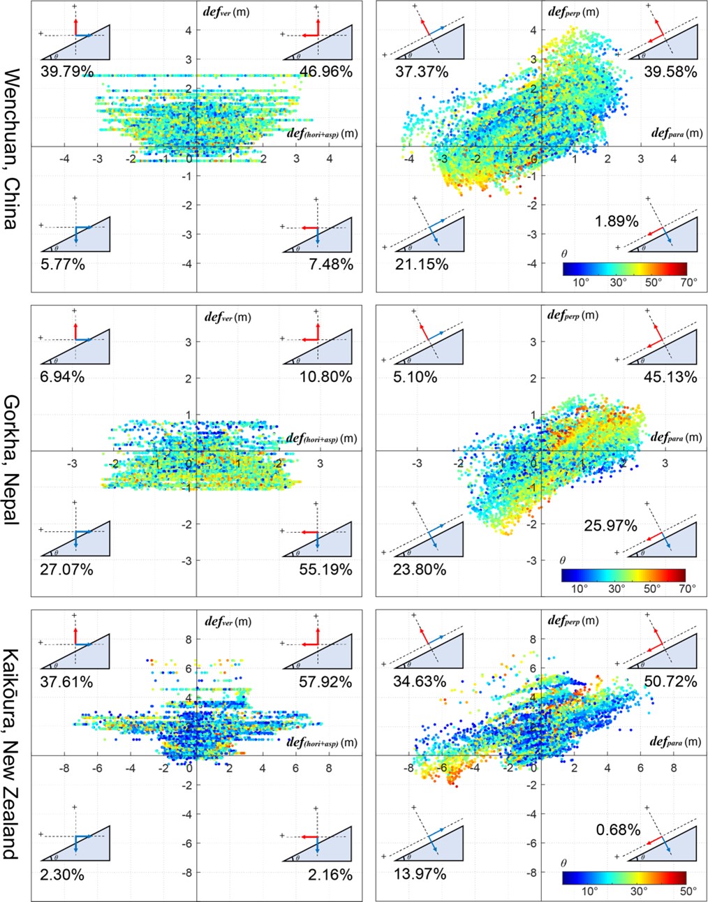
Co-seismic landslides distribution in four quadrants according to the direction of co-seismic displacement at their locations. Each point in the three rows of subplots is a landslide triggered by the Wenchuan, Kaikōura, and Gorkha earthquakes, respectively. The color represents the slope of its location. The first column represents the distribution of coseismic deformations in the horizontal-vertical coordinate system at the location of each coseismic landslide, and the second column represents the distribution of coseismic deformations in the vertical-parallel landslide surface coordinate system at the location of each coseismic landslide. The numbers represent the proportion of the number of coseismic landslides in each quadrant.
同震滑坡根据其所在位置同震位移方向的四象限分布。三行子图中每个点分别是由汶川地震、Kaikōura地震和Gorkha地震所触发的滑坡,颜色代表其所在位置坡度。第一列代表每一个同震滑坡所在位置同震形变在水平-垂直坐标系中的分布;第二列代表每一个同震滑坡所在位置同震形变在垂直-平行滑坡面坐标系中的分布。数字为各个象限同震滑坡数量所占比例。
2023-#1
SAR interferometry (InSAR) has emerged in the big-data era, particularly benefitting from the acquisition capability and open-data policy of ESA’s Sentinel-1 SAR mission. A large number of Sentinel-1 SAR images have been acquired and archived, allowing for the generation of thousands of interferograms, covering millions of square kilometers. In such a large-scale interferometry scenario, many applications actually aim at monitoring localized deformation sparsely distributed in the interferogram. Thus, it is not effective to apply the time-series InSAR analysis to the whole image and identify the deformed targets from the derived velocity map. Here, we present a strategy facilitated by the deep learning networks to firstly detect the localized deformation and then carry out the time-series analysis on small interferogram patches with deformation signals. Specifically, we report following-up studies of our proposed deep learning networks for masking decorrelation areas, detecting local deformation, and unwrapping high-gradient phases. In the applications of mining-induced subsidence monitoring and slow-moving landslide detection, the presented strategy not only reduces the computation time, but also avoids the influence of large-scale tropospheric delays and unwrapping errors. The presented detection-first strategy introduces deep learning to the time-series InSAR processing chain and makes the mission of operationally monitoring localized deformation feasible and efficient for the large-scale InSAR.
合成孔径雷达干涉测量(InSAR)已进入了大数据时代,尤其受益于欧空局哨兵-1 号任务的采集能力和开放数据政策。大量哨兵-1 号合成孔径雷达图像已被获取并存档,从而可以生成数千张干涉图,覆盖面积达数百万平方公里。在这种广域InSAR的背景下,许多应用实际上旨在监测干涉图中稀疏分布的局部形变。因此,将时间序列 InSAR 分析应用于整个图像,并从得到的速度图中识别变形目标的方法存在效率较低的问题。在此,我们提出了一种利用深度学习网络首先探测局部形变,然后对带有形变信号的小尺度干涉图进行时间序列分析的策略。具体来说,我们报告了我们提出的深度学习网络在生成干涉图掩膜、探测局部形变集中区和进行高梯度相位解缠方面的后续示范应用研究。在对采矿引起的沉降监测和缓慢移动的滑坡检测应用中,我们所提出的策略不仅缩短了计算时间,还避免了大尺度对流层延迟和解缠误差的影响。这一探测优先的策略将深度学习引入了时间序列 InSAR 处理链,使利用广域 InSAR 实际监测局部形变的任务变得可行和高效。
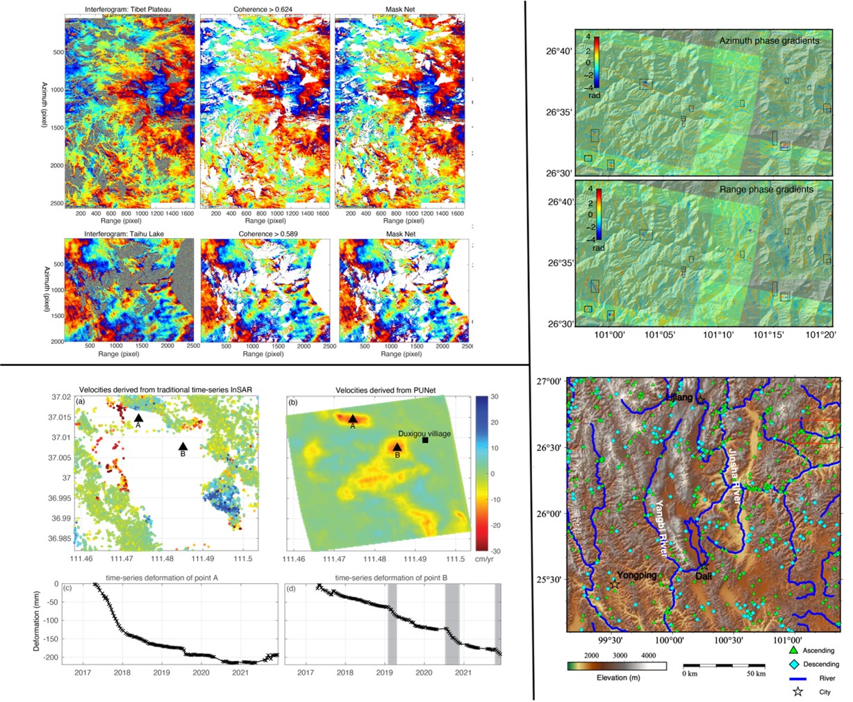
Applications of three deep-learning network proposed by our group. Top-left: The MaskNet for interferogram mask generation with application to Sentinel-1 interferograms. Left-bottom: The PUNet for unwrapping interferograms with mining-induced high-gradient deformation with application to the 2021 undermining water-leakage accident in Xiaoyi, Shanxi province. Right: Slow-moving landslides detected from the phase-gradient stacking map in the northwest Yunnan province, China using the improved YOLO-v3 network.
研究团队近期提出的三种深度学习网络的进一步应用。左上角: 用于生成干涉图掩膜的 MaskNet及其在哨兵-1号干涉图中的应用。左下角:用于对采矿引起的高梯度变形干涉图进行解缠的PUNet,及其在山西孝义 2021 年盗采透水事故中的应用。右图利用改进的 YOLO-v3 网络从相位梯度叠加图中探测到的中国云南省西北部缓慢移动滑坡分布。
2022-#6
Earthquake source parameters are important for understanding earthquake physics and crustal fault properties. However, strong trade-offs between parameters (e.g. depth and origin time) and a lack of accurate velocity models and near-field seismic stations could cause large uncertainties of these parameters in seismic catalogues, particularly for shallow events. To further improve the resolution of earthquake source parameters, we use Interferometric Synthetic Aperture Radar (InSAR) images to derive source solutions of 33 moderate-size (Mw4.1-6.6) earthquakes that occurred at shallow depths (<20 km) from November 2014 to July 2020, in western China. After evaluating the uncertainties of the InSAR solutions, we systematically compare the location, centroid depth, focal mechanism and magnitude from InSAR models with that from seismic catalogues. we find that all seismic catalogues generally report deeper (4-10 km) hypocenter or centroid depths. The uncertainties of moment tensor solutions are partially related to the percentage of the non-double-couple component in the seismic catalogues. The InSAR solutions indicate that considerable seismic moments (i.e. ~{2\times10}^{18} Nm) were released in the uppermost crust (i.e. <5 km) in a period of 6 years, which is not resolvable in the seismic catalogues. The smooth seismic moment distribution along depth indicates a gradual change of the frictional properties from the surface to the middle crust. As most of the studied earthquakes are located on secondary and/or unmapped faults, these findings imply a considerable portion of velocity-weakening friction in the uppermost crust along immature, secondary fault systems, which should be included in the seismic hazard evaluation.
震源参数对于理解地震物理和地壳断层性质至关重要。然而,震源参数(例如深度和震源起始时间)之间的强烈制约以及准确速度模型和近场地震台站的缺乏可能会导致地震目录中的这些参数具有很大不确定性,特别是对于浅层地震。为了进一步提高震源参数的分辨率,我们使用干涉合成孔径雷达(InSAR)数据,获取2014年11月至2020年7月发生在中国西部浅层(<20 km)的33次中小地震(Mw4.1-6.6)的震源模型。在评估InSAR解的不确定性之后,我们系统地比较了InSAR模型和地震目录中的位置、质心深度、震源机制和震级。我们发现,地震目录通常获得更深(4-10km)的震源或质心深度。此外,地震目录得到的矩张量解的不确定性可能与非双偶分量的百分比有关。InSAR震源结果表明,在6年的时间里,最上层地壳(<5km)释放了相当大的地震矩(~{2\times10}^{18}Nm),这在现在地震目录中是无法分辨出来的。地震矩沿深度的平滑分布表明摩擦性质从地表到中地壳渐变式发生变化。由于本文所研究的大多数地震位于次级和/或未发现的断层上,这意味着未成熟次级断层系统的最上层地壳中存在一定的速度弱化的摩擦性质,应将其纳入地震危险性评估中。
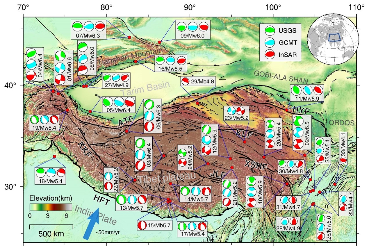
Overview of the 33 studied earthquakes (Mw 4.1–6.6) with the red dots indicating their locations. Beachballs represent focal mechanisms from the U.S. Geological Survey (USGS) catalog (green), Global Centroid Moment Tensor (GCMT) catalog (cyan), and Interferometric Synthetic Aperture Radar (InSAR) inversions (red). Abbreviations of the fault names are ATF-Altyn Tagh fault, KLF-Kunlun fault, LMSF-Longmenshan fault, XSHF-Xianshuihe fault, KKF-Karakorum fault, JLF-Jiali fault, HYF-Haiyuan fault and HFT-Himalayan frontal thrust. The number (1–33) before the magnitude of each event is the sequence number arranged according to their GCMT magnitudes in a descending way. In case the GCMT solution is not available, the USGS solution is used.
本文研究的33个中小地震(Mw4.1-6.6)概览,红色圆点表示其位置。沙滩球(beachball)分别表示USGS目录(绿色)、GCMT目录(青色)和InSAR反演的震源机制(红色)。断层名称缩写为ATF-阿尔金唐古拉断层、KLF-昆仑断层、LMSF-龙门山断层、XSHF-鲜水河断层、KKF-喀喇昆仑断层、JLF-嘉里断层、HYF-海原断层、HFT-喜马拉雅山前冲断层。每个事件震级前的数字(01-33)是根据GCMT目录中震级的降序排列的序列号。如果GCMT目录中没有,则使用USGS目录中的震级。
2022-#5
In transtensional regions, structures striking obliquely to the extension direction generally exhibit oblique or partitioned slips. However, their on-fault partitioning patterns and controlling factors are less known, hindering our understanding of the evolution of the rifting process. Here, we study the slip distribution of the 2021 Mw6.7 Lake Hovsgol (Mongolia) earthquake occurred in a pull-apart basin using InSAR observations. Our preferred slip model shows a remarkable feature, with three zones exhibiting distinct slip directions at different depths. The Coulomb stress change analysis reveals that this pattern is likely controlled by the left-lateral motion of the Mondy Fault to the north, which also inhibits the growth of a boundary fault to the east of the lake, shaping the asymmetric graben structure in this region. Our results imply the important role of major strike-slip faults bounding the pull-apart basin in the formation and evolution of the oblique rift.
在转换拉张区域,伸展方向与区域最大拉张方向间存在夹角的构造通常会表现出斜滑或滑移分配现象。2021年蒙古Mw6.7地震是仪器记录到的发生在Hovsgol拉张盆地内最大震级的地震。本研究利用来自不同传感器的升降轨雷达影像获取了此次事件地表视线向形变并分解得到东西向和垂直向形变场。基于该数据集获得了最佳断层几何及滑移分布。结果表明,此次地震以正断滑动为主兼有明显的右旋走滑分量,倾滑和走滑分布不均匀,断层面上出现滑移分配现象。通过应力分析发现Hovsgol湖北部的大型左旋走滑断层Mondy Fault促进了发震断层的滑移分配,同时抑制了Hovsgol湖东岸西倾正断层的生长,对Hovsgol湖半地堑结构起到塑造作用。
Fault slip distribution of the preferred fault model for the 2021 Mw6.7 Lake Hovsgol (Mongolia) Earthquake. (a–c) Total, strike, and dip slips of the optimal fault model, respectively. The black dots represent aftershocks within 2 months after the mainshock. The beachballs in (a) display focal mechanisms of the Mw6.7 event from this study, USGS, Global CMT, and GFZ. (d) The 3D view of the fault slip distribution.
2021 6.7 Mw6.7 蒙古Hovsgol地震最佳断层滑动分布模型。(a–c)分别为断层总滑动量、走滑量和倾滑量二维分布。黑色圆点表示主震后2个月内的余震分布。(a)中沙滩球分别为本研究、USGS、GCMT和GFZ给出的此次事件震源机制。(d)断层滑动三维分布视图。
2022-#4
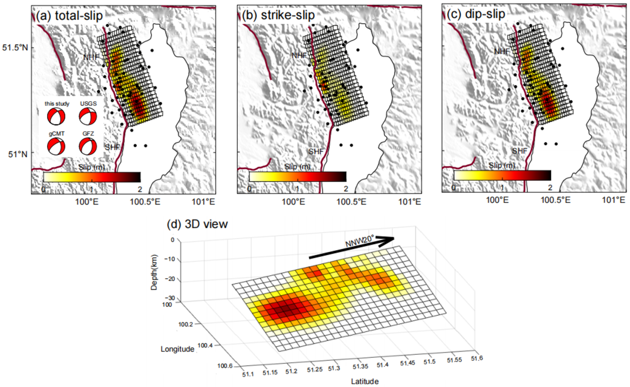
The 1,000 km-long Haiyuan fault is the largest strike-slip fault system in the northeastern Tibetan Plateau, accommodating part of the plateau’s eastward extrusion. However, few large earthquakes have been instrumentally recorded, hindering our understanding of strain partitioning across the fault system. Here, we use synthetic aperture radar images to investigate fault geometries and slip distributions of the adjacent 2016 Mw5.9 and 2022 Mw6.7 Menyuan earthquakes that occurred 35 km apart along the western Haiyuan fault system. The purely strike and purely thrust slips of the 2022 and 2016 events indicate that strain was released separately on shallow steep fault and low-angle fault at depth. We propose that such strain partitioning is controlled by the ratio between interseismic shear and normal velocities and the branching fault structure beneath the Lenglongling segment. Seismic hazard due to both focal mechanisms has to be considered along the western Haiyuan fault in northeastern Tibet. 1000公里长的海原断裂带是青藏高原东北缘最大的走滑断层系统,调节了青藏高原的向东挤压。然而,海原断层上仪器记录的大地震很少,阻碍了我们该断层系统应变分配的理解。我们使用合成孔径雷达图像来研究发生在海原断裂系统西端上相距35公里的2016年Mw5.9和2022年Mw6.7门源地震的断层几何和滑动分布。2022年地震的纯走滑机制和2016年地震的纯逆冲机制表明应变分别在浅部高倾角断层和深部低角度断层上释放。我们认为这种应变分配受震间剪切速度与缩短速率之比以及冷龙岭下方的分支断层几何结构控制。海原断层西端需要同时考虑这两种震源机制地震引起的灾害。
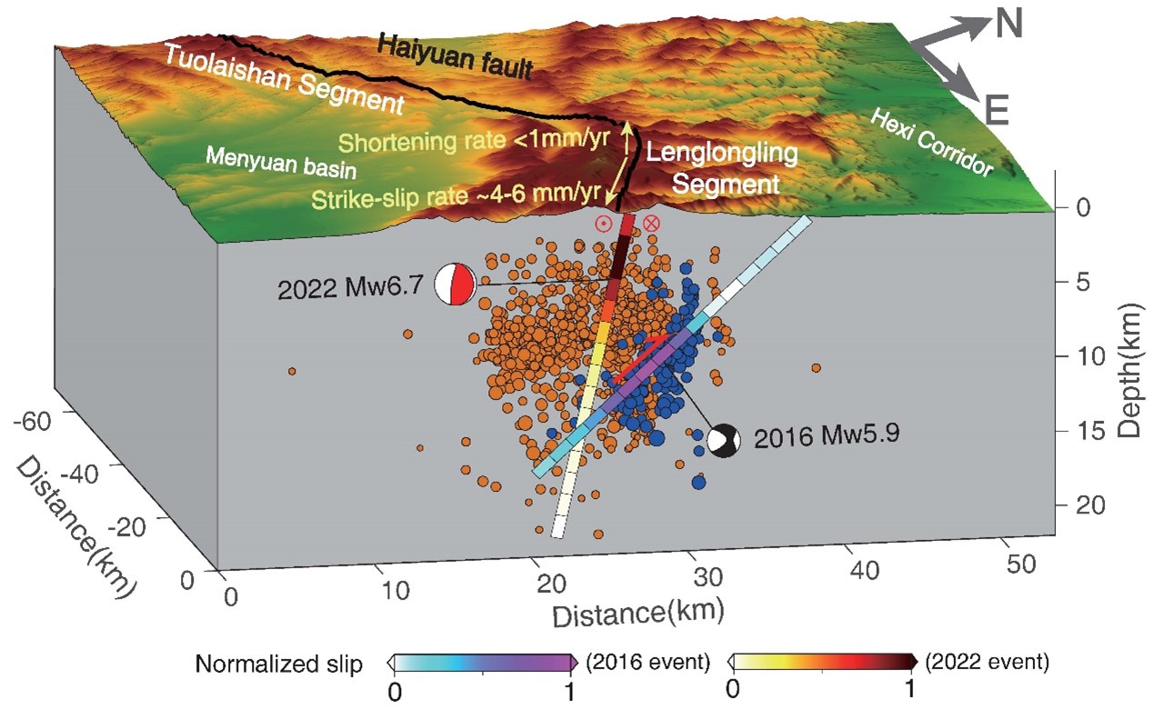
Schematic illumination of 2016 Mw5.9 and the 2022 Mw6.7 Menyuan earthquakes. The fault slips projected on the depth profile are normalized to the maximum averaging slip with projected moment sensors represented as black and red beachballs. The depth profile is perpendicular to the Lenglongling (LLL) fault and the map region is denoted by the red box in Figure 1. Blue and orange dots represent the relocated aftershocks of the 2016 and 2022 events from Liang et al. (2017) and Yang et al. (2022), respectively. Black lines represent the trace of the Haiyuan fault. Note that the shortening rate is less than 1 mm/yr and the strike-slip rate is ∼4–6 mm/yr on the LLL segment from Huang et al. (2022).
2016年Mw5.9和2022年Mw6.7门源地震的示意图。深度剖面垂直于冷龙岭断层,均一化的滑移分布投影到了深度剖面上。蓝色和橙色圆点分别表示两次地震的余震分布。黑线代表海原断层。
2022-#3
Could thermal pressurization have induced the frequency-dependent rupture during the 2019 Mw8.0 Peru intermediate-depth earthquake? 热增压作用是否导致了2019年秘鲁Mw8.0中源地震的频率相关破裂? Luo, H., H. Zeng, Q. Shi, T. Wang, M. Liao, J. Hu, and S. Wei (2022), Could thermal pressurization have induced the frequency-dependent rupture during the 2019 Mw8.0 Peru intermediate-depth earthquake?, Geophysical Journal International, 232(1), 115-127. The rupture process of earthquakes at intermediate-depth (∼70–300 km) have rarely been illuminated by a joint analysis of geodetic and seismic observations, hindering our understanding of their dynamic rupture mechanisms. Here we present detailed rupture process of the 2019Mw8.0 Peru earthquake at the depth of 122 km depth, derived with a holistic approach reconciling InSAR and broad-band seismic waveform data. The joint inversion of InSAR observations and teleseismic body waves results in a finite rupture model that extends ∼200 km along strike, with unilateral rupture towards north that lasted for ∼60 s. There are four major slip patches in the finite fault model which are well corresponding to the position and timing of the sources in back-projection and multiple points source results. The largest slip patch, which occurred ∼40 s after the rupture initiation, had a longer and smoother rise time, and radiated much weaker high-frequency seismic waves compared to other smaller slip patches. This distinct frequency-dependent rupture could be explained by a strong dynamic weakening mechanism. We question whether thermal pressurization of pore free water rather than thermal run away could be such a mechanism. Our frequency content analysis could be generalized to study other earthquakes including those deeper than 300 km.
中等深度地震的破裂过程(∼70–300 km)很少被大地测量和地震观测的联合分析所阐明,这阻碍了我们对其动态破裂机制的理解。本文基于InSAR和宽频带地震波数据,研究了2019年122 km 深度的Mw8.0秘鲁地震的详细破裂过程。InSAR观测和远震体波的联合反演得到了有限破裂模型,其走向长度约200公里,单侧向北破裂,持续时间约为60秒。有限断层模型中有四个主要的滑动区域,它们与反投影和多点源反演方法得到的子事件的位置和时间非常对应。最大的破裂区域在地震发生后40秒开始破裂,与其他三个较小的滑动区域相比,其滑动持续时间更长,辐射的高频地震波更弱。这种与频率有关的断裂可以用动态破裂弱化机制来解释,我们认为该机制由孔隙自由水的热加压而非热熔融引起。本文的震源地震波频率分析可以推广到其他地震研究,包括深度超过300公里的地震。
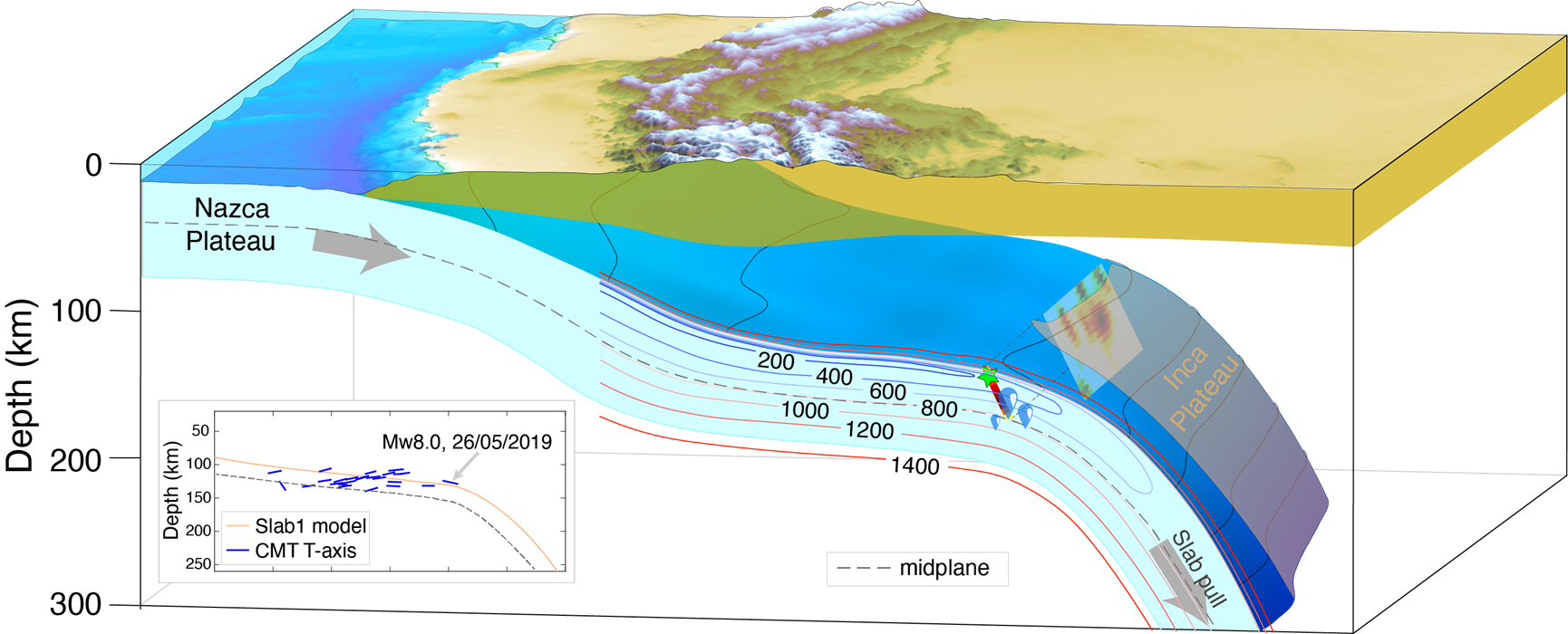
Schematic map of the 26 May 2019 Peru earthquake and subducted Nazca slab in Peru. Thermal structure is represented by coloured lines (details of thermal structure model (Stadler et al. 2010) are shown in Fig. S17). The inset shows the projection of CMT events in this region on a vertical cross-section in the schematic map. Dashed line shows the midplane. Green star in slip projection on the profile represents the hypocentre of the earthquake.
2019年5月26日秘鲁地震以及秘鲁纳斯卡板块俯冲示意图。俯冲板块的温度用彩色线表示。插图显示了该区域地震在剖面上的垂直投影,虚线显示俯冲板块中线。剖面上滑动投影中的绿色五星表示2019年秘鲁地震的震源位置。
2022-#2
Loess deposits are widely distributed in western and central China. Because loess is wet-collapsible, loess mass is prone to failure after water infiltration. Heifangtai, composed of two adjacent typical loess platforms located in the Loess Plateau beside the Yellow River, has experienced hundreds of landslides in the past few decades. Here, we derived surficial time-series deformation, velocity, and amplitude of seasonality from the Sentinel-1 SAR images acquired from October 2014 to March 2021 in the Heifangtai region and studied their relation with precipitation, temperature, and irrigation applying wavelet analysis. The decomposed velocities show that not only a large amount of along-slope deformation occurred surrounding the terrace but also a significant subsidence in the residential area in the middle of the platform was observed. The high seasonality areas are distributed along the Yellow River and on the terrace consistent with other water sources, e.g., springs and irrigation, revealing a promotion of a periodic water-involved process on deformation in loess. Through the wavelet analysis, we found that the temperature is almost in phase with the uplift velocity when the temperature is below the freezing point. The precipitation precedes the surface displacement of ~1 to 2 months for water penetration. The comparison between irrigation volumes and averaged displacements suggests that irrigation also plays a role in promoting subsidence from March to October but uplift in winter due to frost heave. We highlight that the retrogressions of the terraces in this region may be accelerated by both natural and anthropogenic factors. Careful monitoring and water management are highly recommended for the safety of local residences and infrastructures.
黄土在中国分布广泛,因为其湿陷性,黄土体在水入渗后极易发生垮塌和崩落。本文的研究区域——黑方台,坐落在黄土高原之上,位于黄河岸边——在过去的几十年里有数百个滑坡发生。我们应用小基线数据集技术处理了哨兵1号在该区域从2014年10月到2021年3月获取的SAR影像,得到了这段时间地表位移的平均速度和位移和速度的时间序列。之后,我们使用小波变换工具分析了时序数据与降雨量、温度和灌溉量之间的相关性。该区域的平均速度场表明地表形变不仅分布在台塬边界,台塬表面也存在长期的缓慢沉降。季节性位移模型拟合的结果表明拥有较高季节性位移变化的区域不仅大量分布在台塬上,还存在于黄河两岸,且与水源(泉水或灌溉)的空间分布一一对应,这表明周期性的水文变化对黄土的地表形变具有重要的促进作用。通过小波分析,我们发现在温度低于零摄氏度的时间段内,温度与速度时间序列高度相关。使用同样的方法,我们发现降雨量领先地表位移约1-2个月。对比灌溉量和年平均位移时间序列,我们认为灌溉水的入渗对地表沉降有着很大的促进作用,但一旦在冬季当水开始渐渐冻结后,由于冻胀作用,他们反而会产生地表的抬升。在该研究中我们强调,自然和人为因素的共同作用会加速台塬的坍缩和边界的退行,而为了当地住宅和基础设施的安全,我们建议加强当地的地灾观测系统并妥善管理和安排农业用水。
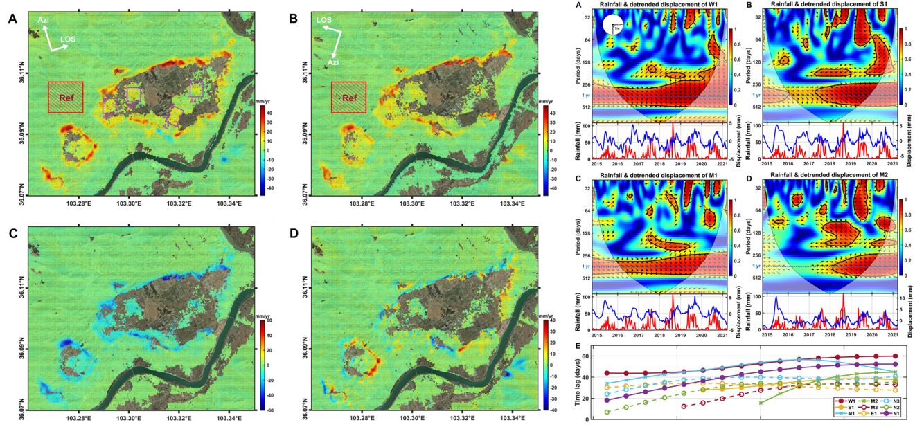
Left: spatial pattern overlaying the optic image for the mean velocities in (A) ascending LOS direction, (B) descending LOS direction, (C) vertical direction, and (D) east–west direction. Right: wavelet coherence (A–D) and progression of time lag (E) on different pairs of time-series data. (A–D) show wavelet coherence between precipitation (red lines) and the displacement (blue lines) of W1, S1, M1, and M2 and variations of the time lag between them, respectively.
左图:叠加在光学图像上的地表速度分布图:(A)升轨雷达视线向(LOS)平均速度;(B)降轨LOS向平均速度;(C)垂直方向的平均速度;(D)东西方向的平均速度。右图:不同时间序列数据对的小波相干图(A-D)和时滞天数(E)。(A-D)分别表示降水(红线)与W1、S1、M1、M2区域的的位移(蓝线)之间的小波相干图以及它们之间的时滞关系。
2022-#1
Landslides are a major geohazard that endangers human lives and properties. Recently, efforts have been made to use Synthetic Aperture Radar Interferometry (InSAR) for landslide monitoring. However, it is still difficult to effectively and automatically identify slow-moving landslides distributed over a large area due to phase unwrapping errors, decorrelation, troposphere turbulence and computational requirements. In this study, we develop a new approach combining phase-gradient stacking and a deep-learning network based on YOLOv3 to automatically detect slow-moving landslides from large-scale interferograms. Using Sentinel-1 SAR images acquired from 2014 to 2020, we developed a burst-based, phase-gradient stacking algorithm to sum up phase gradients in short-temporal-baseline interferograms along the azimuth and range directions. The stacked phase gradients clearly reveal the characteristics of localized surface deformation that is mainly caused by slow-moving landslides and avoids the errors due to phase unwrapping in partially decorrelated areas and atmospheric effects. Then, we trained the improved Attention-YOLOv3 network with stacked phase-gradient maps of manually labeled landslides to achieve quick and automatic detection. We applied our method in an ~180,000 km2 area of southwestern China and identified 3,366 slow-moving landslides. By comparing the results with optical imagery and previously published landslides in this region, the proposed method can achieve automatic detection over a large area precisely and efficiently. From the derived landslide density map, we determined that most landslides are distributed along the three large rivers and their branches. In addition to some counties with known high-density landslides, approximately 10 more counties with high landslide density were exposed, which should attract more attention to their risks for geohazards. This application demonstrates the potential value of our newly developed method for slow-moving landslide detection over a nation-wide area, which can be employed before applying more time-consuming time-series InSAR analysis.
滑坡是威胁生命财产安全的主要地质灾害之一。近些年来,合成孔径雷达干涉测量(InSAR)在对滑坡的识别探测中得到了广泛研究,然而,相位解缠错误,失相干、大气扰动以及计算资源限制等原因限制了InSAR在大范围内有效自动识别滑坡的能力。在本研究中,我们提出了结合相位梯度叠加和深度学习网络在大尺度干涉图集中自动探测活动滑坡的方法。利用2014至2020年的哨兵1号SAR影像,我们发展了一种基于burst的相位梯度叠加算法,在生成的短时间基线缠绕干涉图中分别在方位向和距离向上计算相位梯度并进行缠绕叠加。叠加的相位梯度清晰的揭示了局部地表形变聚集区特征,避免了解缠误差和大气效应的影响。我们对工业界广泛应用的小目标识别网络YoloV3进行改进,通过在叠加的相位梯度图中手动标记的活动滑坡进行训练,从而实现对活动滑坡局部形变聚集区的快速自动探测。应用提出的算法,我们在中国西南山区约18万平方公里的区域内识别了3366个活动滑坡,通过与光学影像和区域内已发表的结果对比,验证了提出的方法在广域范围内准确探测滑坡的有效性。活动滑坡密度图显示,大多数活动滑坡沿河流干流及其支流分布。除了部分已知的处于滑坡高密度区域的县城,我们还发现了超过10个县城也处于滑坡高密度区域。初步应用显示,本研究提出的活动滑坡探测方法可在十分耗时的InSAR时序分析之前进行探测工作,具有在广域尺度应用的潜力。
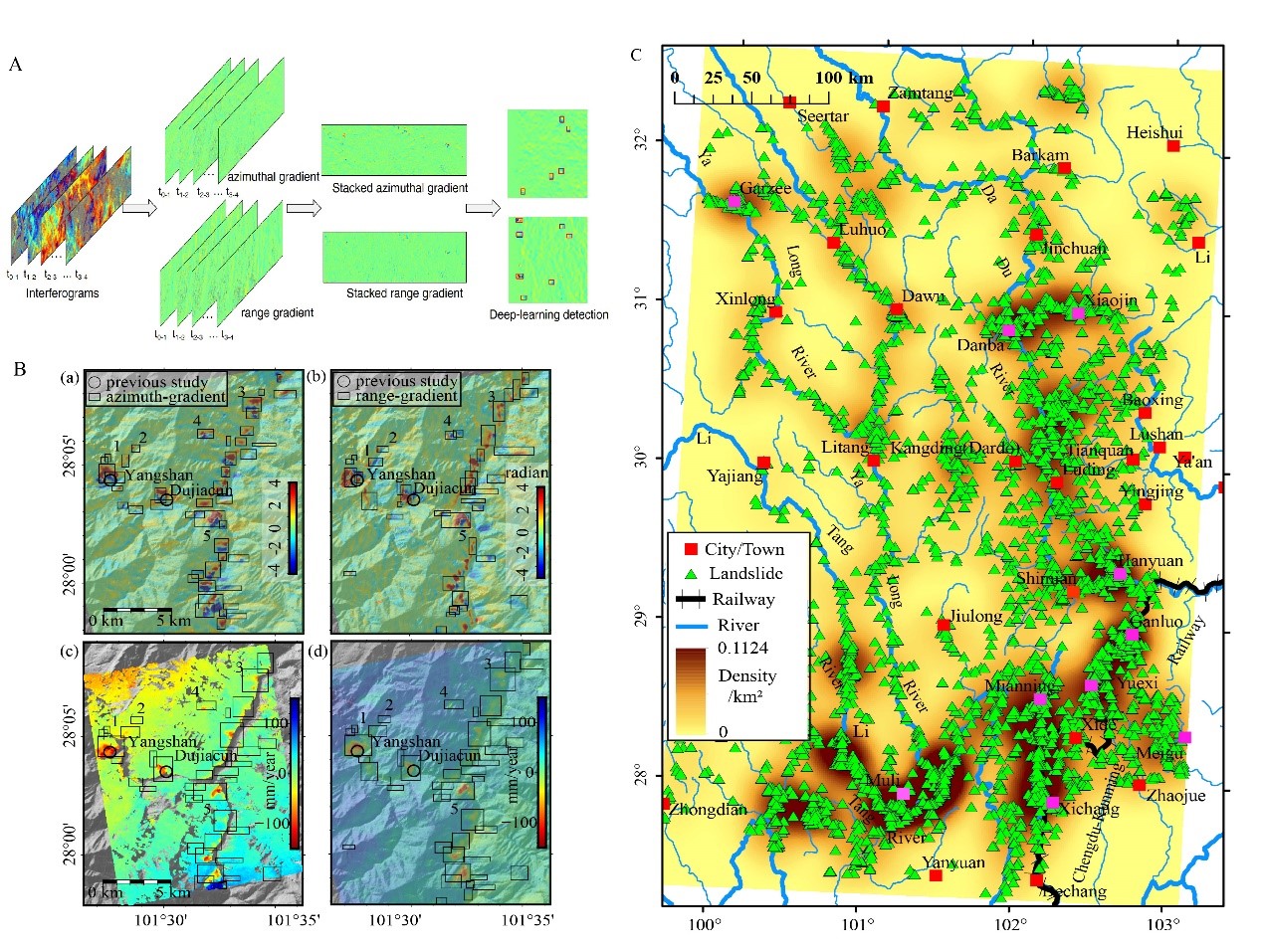
(A) Workflow of the proposed method for one burst image. The phase-gradients stacking and detection are both performed in the radar coordinate for each burst of interferograms. (B) Slow-moving landslides in the middle section of Yalong River detected by Attention-YOLOv3 in phase-gradient maps along azimuth (a) and range (b) directions. Surface velocity maps derived by SBAS-InSAR method (c) and unwrapped-phase stacking (d) for the same area. Black boxes are merged results from (a) and (b), with numbers indicating weak signal in the InSAR velocity maps. Circles show Yangshan and Dujiacun landslides studied in previous studies (Dai et al. 2020). (C) Landslide density map based on our detection result with county locations in the studied region.
(A) 基于burst的相位梯度叠加算法处理流程,每个burst的相位梯度叠加和探测均在雷达坐标系下完成。(B)雅砻江中段结合相位梯度叠加和Attention-YOLOv3网络在方位向(a)和距离向(b)上探测到的活动滑坡(黑色框)。相同区域使用小基线方法(c)和解缠相位叠加(d)的对比结果,图中黑色框为(a)和(b)中的黑色框的合并结果。黑色圆圈标出了此范围内已发表的活动滑坡结果。(C) 研究区内的探测到的滑坡密度图。
2021-#6
The Keping-tage fold-and-thrust belt in southwest Tian Shan is seismically active, yet the most well-recorded earthquakes occurred south of the mountain front. The lack of large earthquakes beneath the fold-and-thrust belt thus hinders our understanding of the orogenic process to the north. The 2020 Mw 6.0 Jiashi earthquake is an important event with surface deformation in the fold-and-thrust belt well illuminated by Interferometric Synthetic Aperture Radar, providing an opportunity to study the present day kinematics of the thrust front through the analysis of satellite measurements of surface deformations. Here, we employ the surface deformation and relocated aftershocks to investigate the fault-slip distribution associated to this event. Further added by an analysis of Coulomb stress changes, we derive a fault model involving slips on a shallow, low-angle (~10°) north-dipping thrust fault as well as on a left-lateral tear fault and a high-angle south-dipping reverse fault in mid-crust. Aftershocks at depth reflect the basement-involved shortening activated by a thin-skinned thrust faulting event. In addition, this earthquake uplifted the southernmost mountain front with relatively low topography, indicating the basin-ward propagation of the southwest Tian Shan.
天山西南部的柯坪塔格逆冲推覆体地震活跃,但有观测记录的地震主要发生在塔里木盆地,逆冲推覆体下方地震观测较少。2020年的Mw6.0伽师地震发生在逆冲推覆体前缘与塔里木盆地交界区域,我们利用InSAR技术获得了此次地震在逆冲推覆体造成的地表形变,并结合余震重定位观测确定了此次事件的发震断层几何及滑移分布。进一步结合库仑应力变化分析,我们认为此次事件包含三断层破裂:柯坪塔格推覆体前缘的柯坪断层浅部低倾角段(~10.2°)、深部滑脱面下的左旋走滑断层和塔里木盆地下方的高倾角基底断层。主破裂区以东的余震表明可能存在右旋走滑盲断层,连同西侧的左旋走滑断层,呈现出以两个撕裂断层为界的类盒状挤压结构。我们推测深部走滑撕裂断层可能延伸至逆冲褶皱带以南,以调节柯坪塔格推覆体前缘不一致的缩短速率。此次地震在地形较低的造山带前缘造成地表抬升,表明西南天山造山形变向盆地侧的进一步拓展。
Map views of the slip distributions on (a) the shallow north-dipping fault and (b) the deep south-dipping and strike-slip faults inferred from aftershock distribution. Red, orange, and yellow beachballs depict the focal mechanism of the north-dipping thrust fault, the deep strike-slip fault and the south-dipping reverse fault, respectively. Circles represent relocated aftershocks. (c-h) Observed, predicted and the residual maps based on our preferred Model for the ascending (top row) and the descending tracks (bottom row).
最佳断层模型滑移分布及数据拟合。(a)浅部北倾低倾角断层和(b)根据余震分布推断的深部南倾高倾角断层上的滑移分布。红色、橙色和黄色的震源球分别为北倾逆冲断层、深部走滑断层和南倾断层的震源机制。圆圈代表重新定位的余震分布。(c-h)为模型数据拟合情况。(c和f)原始观测值;(d和g)模型正演值;(e和h)拟合残差。
2021-#5
This paper proposes deep convolutional neural networks to detect and map localized, rapid subsidence caused by mining activities using time-series Sentinel-1 SAR images. A deformation detection network (DDNet) is developed to automatically identify rapidly subsiding areas from wrapped interferograms, and a phase unwrapping network (PUNet) is designed to unwrap the cropped interferogram patches centered on the detected subsiding locations. To train the two networks, interferogram simulation strategies are developed to generate various training samples using the distorted two-dimensional Gaussian surface and fractal Perlin noises. The performance of the DDNet is verified by simulations on a synthetic dataset with 13 large interferograms, while the PUNet is evaluated by simulations using synthetic datasets with different levels of deformation gradients and noises. Compared with the traditional and deep-learning methods, the PUNet exhibits excellent performance and efficiency in unwrapping interferograms with rapid mining-induced deformation. The proposed networks are further verified by applying them to Shanxi Province, China, which is characterized by serious ground subsidence hazards caused by long-term coal mining activities. The time-series deformations of 1,344 detected subsidence areas are calculated with the vertical velocities ranging from -19.7 cm/year to -254.8 cm/year. The results are validated using the ascending and descending Sentinel-1 Interferograms and an L-band ALOS-2 interferogram covering the same area within the acquisition period, showing highly consistent vertical deformation rates. The proposed strategy and methods introduce deep learning to the time-series InSAR processing chain and may have profound implications on the detection and monitoring of localized mining-induced deformation using InSAR.
本文提出了利用深度卷积神经网络和时间序列哨兵-1 SAR图像对采矿活动引起的局部快速沉降进行自动化探测和时序分析的数据处理策略和方法。其中形变探测网络(DDNet)用于从缠绕的干涉图中自动识别快速沉降的区域;相位解缠网络(PUNet)用于解缠探测到的沉降位置为中心的干涉图切片。为了训练这两个网络,我们开发了一套沉降漏斗干涉图模拟方法,使用扭曲的二维高斯表面和分形Perlin噪声产生各种训练样本。DDNet 的性能通过在13 景模拟干涉图数据集上进行验证,而 PUNet 则通过使用具有不同形变梯度和噪声水平的模拟数据集来评估,并使用升降轨哨兵-1干涉图和覆盖同一地区的L波段ALOS-2干涉图实际验证了解缠效果。所提出的网络通过在中国山西省的应用得到了进一步验证,从2018年9月10日至2019年11月16日获取的哨兵-1数据中共探测到 1,344 个沉降漏斗区域,并获取它们的年度形变序列。其中最大垂直形变速率范围从 -19.7 厘米/年到 -254.8 厘米/年。与传统和其他深度学习解缠方法相比,PUNet 在解缠采矿引起的快速形变干涉图方面表现出优异的性能和效率。我们所提出的策略和方法将深度学习引入到时间序列InSAR处理链中,并对利用InSAR探测和监测局部形变异常提供了新的思路。
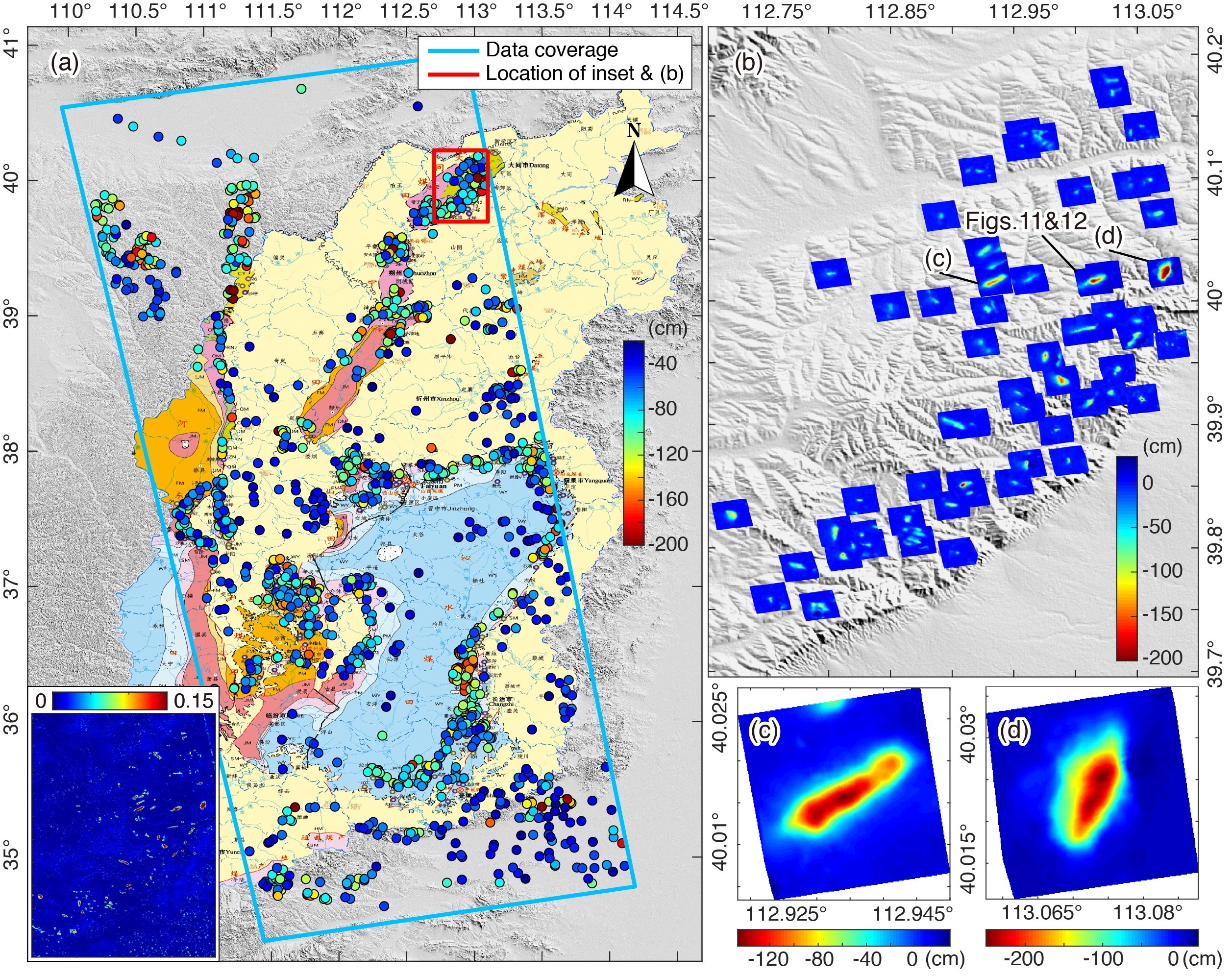
Monitoring results of the local subsidence areas in the Shanxi Province from 10 Sep 2018 to 16 Nov 2019, projected to the vertical direction, where a negative value, i.e., red, represents subsidence. (a) 1344 detected subsidence areas are superimposed on the distribution of coal resources in the Shanxi Province. The color of the point indicates the maximum cumulative subsidence. For visualization, all values smaller than -200 cm are set to the same color as that corresponding to the value of -200 cm. Inset shows the averaged normalized deformation in the radar coordinate obtained by the DDNet on 36 interferograms. The cumulative subsidence distributed within the red rectangle in (a) is shown in (b), while details of the two local subsidence areas are shown in (c) and (d).
2018年9月10日至2019年11月16日山西省局部沉降区的监测结果,投影至垂直方向,其中负值,即红色,代表沉降。(a) 1344个探测到的沉降区叠加在山西省的煤炭资源分布图上。点的颜色表示最大累积沉降量。为了可视化,所有小于-200厘米的点都被设置为与-200厘米相同的颜色。插图显示的是DDNet在36张干涉图上得到的雷达坐标系的平均归一化形变。(b)中显示了分布在(a)中红色矩形区域内的累积沉降量,而(c)和(d)中显示了两个局部沉降区域的细节。
2021-#4
Phase unwrapping is a critical step of interferometric synthetic aperture radar (InSAR) processing, and its accuracy directly determines the reliability of subsequent applications. Many phase unwrapping methods have been proposed, most of which assume that the phase has spatial continuity, while decorrelation noise and aliasing fringes invalidate the assumptions, resulting in poor performance of these methods. To obtain more reliable unwrapping results, in this paper, a deep convolutional neural network, called DENet, is proposed for predicting the probabilities of phase discontinuities in interferograms. The main advantages of DENet are: (1) using branching structure to extract detailed and high-level features separately, to retain details while making full use of contextual information; (2) using multi-channel input, including interferogram, range/azimuthal phase gradients, and residues map, to provide effective guidance for discontinuity prediction; and (3) using a single network to estimate phase discontinuities in both range and azimuth directions simultaneously. To train the network, a data set simulation strategy is proposed to generate enough training samples. The strategy considers a variety of phase components such as terrain-related phase, random deformation, atmospheric turbulence, and noise. The phase discontinuity estimated by DENet is then converted to costs in the minimum cost flow solver of SNAPHU to obtain the final unwrapped phase. Based on validations of simulated and real interferograms, the proposed method exhibits excellent performance compared to traditional and deep learning unwrapping methods. The proposed method can effectively unwrap large-scale, low-quality interferograms, which is expected to significantly improve the accuracy of InSAR applications.
相位解缠是合成孔径雷达干涉测量(InSAR)数据处理的一个关键步骤,其准确性直接决定了后续应用的可靠性。许多相位解缠方法已被提出,其中大多数方法假设相位具有空间连续性,而去相关噪声和混叠条纹使该假设失效。当无法准确判断发生相位不连续的位置时,很多方法的解缠性能会显著下降。基于此问题,本文提出了一个深度卷积神经网络:DENet,用于预测干涉图中所有位置出现相位不连续的概率,用于辅助传统的最小费用流解缠算法。DENet的主要优点是:(1)利用分支结构分别提取细节和高层特征,在保留细节的同时充分利用上下文信息;(2)利用多通道输入,包括干涉图、距离向/方位向相位梯度和残数图,为不连续预测提供有效指导;(3)利用单一网络同时估计距离向和方位向的相位不连续。为了训练网络,我们提出了一个数据集模拟策略来生成足够的训练样本。该策略考虑了各种相位成分,如与地形有关的相位、随机形变、大气湍流和噪声。然后,由DENet估计的相位不连续被转换为SNAPHU中最小费用流求解器中的费用,用于获得最终的解缠相位。基于对模拟和真实干涉图的验证,与传统和深度学习解缠方法相比,本文所提出的方法表现出优异的性能,可以有效地解缠大尺度、低质量、复杂条纹分布的干涉图,有望显著扩展InSAR应用的领域。
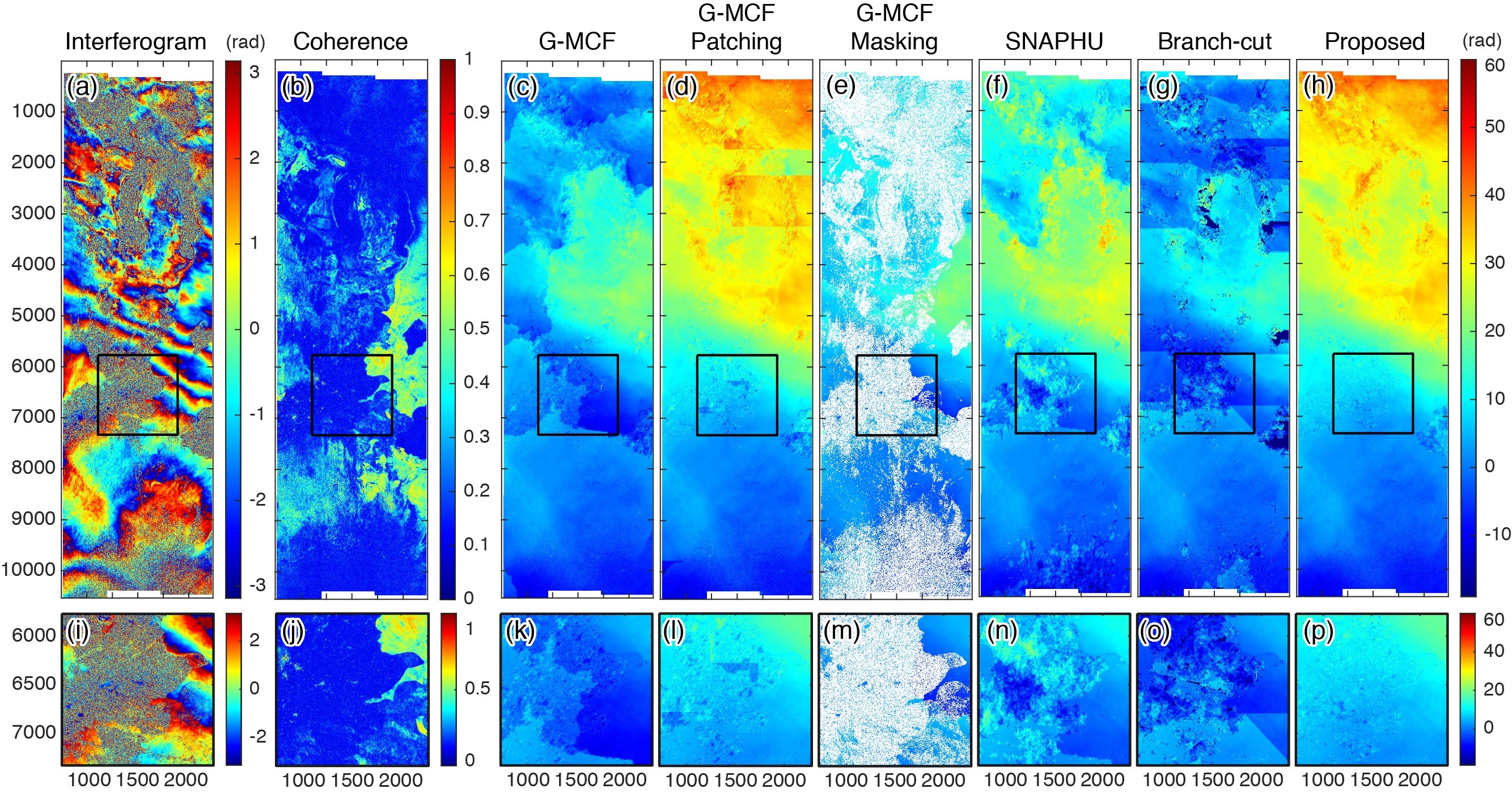
Unwrapping results of different methods on large-scale interferograms. A descending-track Sentinel-1 interferogram containing five frames acquired between 12 May and 23 Jul 2019 is shown in (a), with a coverage area of approximately 860 km × 255 km. There are obvious atmospheric artifacts in the interferogram. Large decorrelated areas are also distributed in a few places, exhibiting low values in the coherence map as shown in (b). The proposed method was applied to unwrap such large-scale interferograms, and the result was compared with those of reference methods, as shown in (c)-(h).
大尺度干涉图上不同方法的解缠结果。(a)显示的是2019年5月12日至7月23日期间获取的包含五个标准幅的降轨Sentinel-1干涉图,其覆盖面积约为860公里×255公里。干涉图中存在着明显的大气延迟相位,同时被完全失相干的水域所分割。这些区域在相干图中表现为低值,如(b)所示。本文提出的方法被应用于解缠这种大规模的干涉图,并将其结果与参考方法进行了比较,如(c)-(h)所示。其中G-MCF,G-MCF patching和G-MCF masking分别为应用GAMMA软件中的MCF解缠方法,用该方法的分块模式和加入掩膜模式进行解缠的结果。
2021-#3
Synthetic aperture radar interferometry (InSAR) is a remote sensing tool that can accurately map terrain and surface deformation with high resolution. Decorrelation is one of the main limitations for InSAR. Masking decorrelated pixels is crucial for retrieving information from SAR interferograms. However, for traditional masking methods, manually drawing masks is time-consuming and may be unfeasible when decorrelation areas are with complicated and blurred boundaries. Setting a single coherence threshold is also difficult, if not impossible, to mask out all decorrelated pixels without losing valid phases. Here, we propose a deep-learning segmentation network (Mask Net) based on Selective Kernel Res-Attention UNet, for generating decorrelation masks with applications to TanDEM-X interferograms. We conduct several experiments to determine the training strategy and parameters, including sample size, batch size, loss function, and down-sampling scheme, to optimize network performance. Afterwards, we compare the performance of Mask Net with other classical segmentation networks. Our evaluation metrics show that Mask Net outperforms the best performance of other segmentation networks by IoU of 6.32% and F1 Score of 3.97%, respectively. It also possesses the fastest inferring speed, 0.4505 s on sample size of 1024-by-1024 pixels, which is at least ∼50% faster than other segmentation networks. We applied Mask Net to three TanDEM-X interferograms of Kīlauea crater in Hawaii, metropolitan region of Wuhan, and Muztagata Glacier in China. Our results show that comparing with coherence threshold method, Mask Net can clearly mask out all decorrelation regions, rarely causing loss of valid phases. It also exhibits better segmentation performance than other deep-learning segmentation networks, especially for those complex decorrelation boundaries, with less computational time. We believe that in the InSAR big data era, such a network can greatly reduce time and labor.
合成孔径雷达干涉测量(InSAR)是一种能够高分辨率精确测绘地形和地表形变的遥感工具。失相干是其主要的限制之一。通过掩膜去除干涉图中的失相干相位对提取有效信息至关重要。然而,对于传统的掩膜方法,手工绘制掩模的方法费时费力,并且在失相干相位的边界十分复杂和模糊时,这种方法几乎不可行。对于阈值法,单一的相干阈值很难或几乎不可能在不造成有效相位损失的情况下对所有的失相干相位进行掩膜。因此,我们提出一个深度学习语义分割网络,Selective Kernel Res-Attention UNet (Mask-Net),用于生成失相干掩模,并将其应用于TanDEM-X卫星干涉图。为了最大化网络的分割性能,我们设计了多组的权衡实验来确定最佳的网络训练策略,包括最佳样本大小、批训练样本量、损失函数以及下采样方案。然后,我们将本网络与其他经典的分割网络的性能进行了比较。结果表明,Mask-Net的分割性能优于其他经典的分割网络,其中语义分割评价指标IoU和F1-Score分别优于其他经典分割网络最佳性能的6.32%和3.97%。并且本网络具有最快的处理速度,在1024×1024 像素的样本尺寸上仅为0.4505s,超过其他分割网络的最快速度推理速度约50%。最后我们将本网络应用到美国夏威夷Kīlauea火山口、中国武汉城区以及中国西部穆兹塔加塔冰川的TanDEM-X干涉图上,结果表明,Mask-Net可以在那些模糊、微小和复杂的失相干边界上生成准确的掩模。与相干阈值法相比,本网络可以准确地掩膜失相干相位,而很少造成有效相位的损失或破坏其连续性。与其他经典的分割网络相比,本网络在那些微小复杂,模糊的失相干边界上具有更好的分割性能,同时具有最快的推理速度。我们相信,在InSAR大数据时代,这样的网络可以大大节省时间和人力。
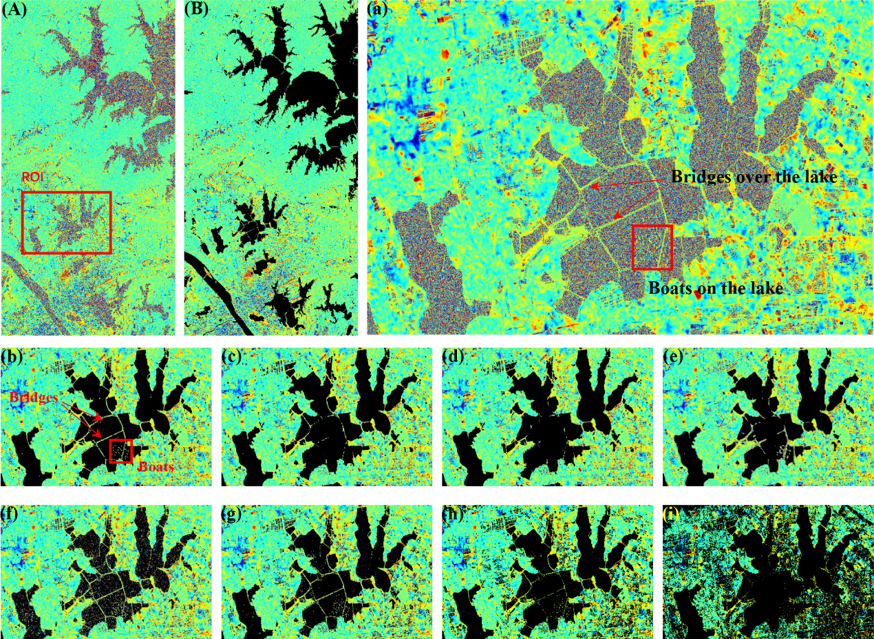
Decorrelation masks of the TanDEM-X interferogram covering the Wuhan metropolitan region in china using deep-learning networks and different coherence thresholds. (A) Interferogram of Wuhan district (in radar coordinate: 2832-by-5699 pixels). (B) Masked interferogram by applying the Mask Net. (a) Interferogram of ROI (in radar coordinate: 1440-by-992 pixels). (b–e) represent interferograms of ROI-masked by the Mask Net, DeeplabV3+, ResUNet, FCN-8s, respectively. (f–i) represent interferograms of ROI masked by coherence thresholds of 0.2, 0.4, 0.6, 0.8, respectively
使用深度学习网络及相干性阈值法得到的中国武汉城区TanDEM-X掩膜干涉图 (A) 中国武汉城区TanDEM-X干涉图 (雷达坐标系:2832×5699 像素)。(B) Mask-Net得到的掩膜干涉图 (a) ROI区域的干涉图 (雷达坐标系:1440×992 像素)。(b-e) 表示分别使用Mask-Net, DeepLabV3+, ResUnet,FCN-8s得到ROI区域的掩膜干涉图。 (f-i) 分别表示使用相干性阈值分别为0.2,0.4,0.6,0.8得到的ROI区域的掩膜干涉图。
2021-#2
The moment magnitude (Mw) 6.4 and 7.1 Ridgecrest earthquake sequence occurred on 4th and 6th July 2019, ruptured a conjugate fault system within the eastern California shear zone. In addition to the ~50 km surface ruptures, the sequence activated a series of structures with lengths ranging from 1 to 10 km, which are well illuminated by phase gradient maps of Synthetic Aperture Radar (SAR) interferograms. The deformation patterns and mechanisms of these fractures has been well studied, yet the controlling factors of their spatial distribution are less discussed, which are important for understanding how the accumulated strain is released via distributed faulting in the earthquake cycle. Here, we use multi-source SAR images to derive 3-dimensional (3D) surface displacement along the main ruptures and the east-west strain across the detected small fractures caused by the 2019 Ridgecrest earthquake sequence. We find that the distribution of these fractures is related to the displacement pattern along the main rupture. Specifically, more fractures appeared in areas with larger slips normal to the main rupture as well as in the junction of the conjugated ruptures. We also conduct uniaxial loading rock experiments to evaluate the strain distribution before the samples were broken. Rock experiments show that rupturing of a conjugated fault system may produce local strain concentration along the main rupture, indicating the important role of the orthogonal faults in generating small fractures with different striking angles and deformation patterns. The 2019 Ridgecrest earthquake sequence exhibits complicated crust behaviors by rupturing an immature fault system, implying that the simple elastic rebound theory may be insufficient to model the coseismic deformation during the earthquake cycle, particularly in the zone with weak crust.
2019年7月4日和6日矩震级为6.4和7.1的Ridgecrest地震序列,破裂了加利福尼亚东部剪切带 (eastern California shear zone, ECSZ) 内的一个共轭断层系统。这个地震序列除了造成约50 km的地表破裂外,还激活了一系列被合成孔径雷达 (Synthetic Aperture Radar, SAR) 干涉相位梯度图所揭示的长度为1~10公里的小裂隙。这些小裂隙的变形模式和机制已经得到了很好的研究,但关于它们空间分布的控制因素的讨论却很少,这些因素对于理解地震周期中积累的应变是如何通过分布断层释放的具有重要意义。这里,我们使用了多源SAR图像获取了2019年Ridgecrest地震序列引起的主破裂带沿线的三维地表位移和小裂隙所在位置的东西向应变。我们发现这些小裂隙的分布与主破裂沿线的位移模式有关。具体来说,在主破裂法向位移较大的区域以及共轭断层的交界处,小裂隙的密度较高。我们还进行了单轴加载岩石试验以评估岩石样品破坏前的应变分布。岩石实验的结果表明,共轭断层系统在破裂过程中可能会沿着主破裂产生局部应变集中,这也显示了正交断层对不同走向和变形模式的小裂隙形成所起的重要作用。2019年的Ridgecrest地震序列通过破坏一个不成熟的断裂系统表现出复杂的地壳形变行为,这意味着简单的弹性回跳理论可能不足以模拟地震周期内的同震变形,特别是在地壳较弱的地区。
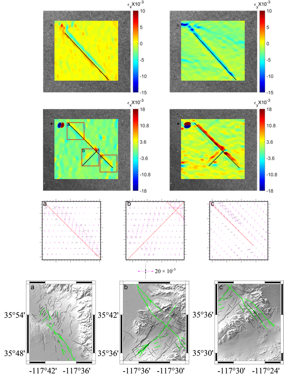
Strain fields observed before the broken of marble samples. Colors represent the strain in the direction of X-axis (A) and Y-axis (B) of the marble sample with only one prefabricated fault and of the marble sample with two orthogonal prefabricated faults (C and D, respectively). Positive values indicate tensional strain along the corresponding axis while the negative values indicate compressional strain along the axis. The black line indicates the prefabricated fault and the loading direction is along the negative direction of Y-axis. The principal strain axes within the red rectangles in (C) are shown in (E). The red lines indicate the prefabricated faults, and the black lines represent the compression while the magenta lines represent extension. Surface fractures produced by earthquake sequence in the corresponding areas are shown in (F) for comparison.
大理岩样品破裂前的应变场特征。颜色代表只有一条预制裂纹的大理岩样品 (A~B) 和两条正交共轭预制裂纹裂纹的大理岩样品 (C~D) 在X方向上和Y方向上的应变。正值表示相应方向的拉张应变,负值表示相应方向的压缩应变。黑色直线显示的是预制裂纹的位置,加载的方向沿Y轴负向。图 (C) 中红色矩形区域内的主应变轴如图 (E) 所示。红色线表示预制裂纹,黑色线表示压缩应变,品红色线表示拉张应变。相应地区地震序列产生的地表破裂如图 (F) 所示。
2021-#1
Small-to-moderate earthquakes (e.g. ≤Mw5.5) occur much more frequently than large ones (e.g. >Mw6.0), yet are difficult to study with InSAR due to their weak surface deformation that are severely contaminated by atmospheric delays. Here we propose a stacking method using time-series SAR images that can effectively suppress atmospheric phase screens and extract weak coseismic deformation in centimeter to sub-centimeter level. Using this method, we successfully derive coseismic surface deformations for three small-to-moderate (Mw∼5) earthquakes in Tibet Plateau and Tienshan region from time-series Sentinel-1 SAR images, with peak line-of-sight deformation ranging from 5mm to 13 mm. We also propose a strategy to downsample interferograms with weak deformation signal based on quadtree mesh obtained from preliminary slip model. With the downsampled datasets, we invert for the centroid locations, fault geometries and slips of these events. Our results demonstrate the potential of using time-series InSAR images to enrich earthquake catalog with geodetic observations for further study of earthquake cycle and active tectonics.
中小型地震(≤Mw5.5)的发生频率远高于大型地震(>Mw6.0),但由于其微弱的地表形变易受到大气延迟的严重干扰,这些地震往往难以利用InSAR进行研究。因此,我们提出了一种基于时间序列SAR影像的stacking方法,该方法可以有效地抑制大气相位屏,提取厘米级甚至亚厘米级的微弱同震地表形变。利用该方法,基于时间序列哨兵 SAR影像,我们成功地提取了西藏和天山地区3个中小地震(Mw∼5)的同震地表形变,其视线向形变峰值为5-13mm。针对这种微小同震形变,我们还提出了一种新的降采样策略,该策略基于初步滑移模型得到的四叉树网格对原始观测数据进行二次降采样。基于这些降采样数据,我们反演了这些地震的震中位置、断层几何和滑移向量。我们的结果表明,时间序列SAR数据具有巨大的潜力对震源模型提供大地测量观测约束,从而促进地震周期和活动构造的研究。
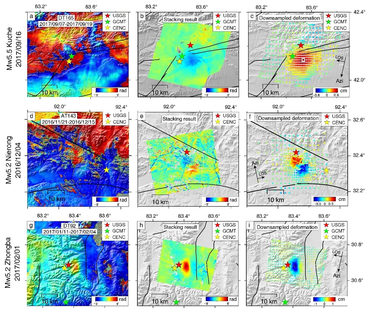
Single coseismic interferograms and final deformations derived using the proposed method. From top to bottom rows: the 2017 Mw5.5 Kuche, 2016 Mw5.2 Nierong, and 2017 Mw5.2 Zhongba earthquakes
同震干涉图结果和基于时间序列SAR数据stacking处理及降采样后的同震形变分布。从上到下分别为:2017 Mw5.5 库车地震, 2016 Mw5.2 聂荣地震和2017 Mw5.2 仲巴地震
2020-#1
Space imaging geodesy reveals near circular, coseismic block rotation during the 2016 Mw 7.8 Kaikōura earthquake, New Zealand 空间影像大地测量在2016年新西兰凯库拉地震中揭示的近圆形同震块体旋转 Wang, T., Jiao, L., Tapponnier, P., Shi, X., & Wei, S. (2020). Space imaging geodesy reveals near circular, coseismic block rotation during the 2016 Mw 7.8 Kaikōura earthquake, New Zealand. Geophysical Research Letters, 47, e2020GL090206. Large earthquakes usually rupture plate boundary faults, releasing the accumulated stress as displacements localized along smooth, narrow faults. However, certain earthquakes initiate off main faults, rupturing adjacent, secondary faults. The mechanisms of such atypical stress release remain enigmatic, partly due to a lack of detailed geodetic evidence. Here using the 3D coseismic displacement field derived from space imaging geodesy, we detect 10‐km‐scale, nearly‐circular coseismic block rotation during the 2016 Mw 7.8 Kaikōura earthquake in New Zealand. Together, geodetic observations, longer term local paleomagnetic data, analytical, and discrete element modeling imply that localized block rotation occurred south of the Hope fault along weak, steep, bedding‐parallel boundaries within a narrow, ~20‐km‐wide dextral shear zone. That stress near plate boundary faults can be partially released in zones of distributed ruptures absorbing coseismic rotation may retard rupture along main faults. Our observations also suggest that coseismic rotation may help accomodate plate boundary propagation.
大地震通常会通过在板块边界断层发生破裂,将累积的应力以局部位移和应变的形式,沿平滑、狭窄的断层释放出来。然而,某些地震从主断层外开始成核,只破裂相邻的次级断层。这种非典型的应力释放的机制仍然是个谜,部分原因是缺乏详细的大地测量证据。这里,利用空间影像大地测量获得的三维同震形变场,我们在2016年新西兰Mw7.8凯库拉地震中发现了十公里尺度、近圆形的块体旋转。大地测量观测、古地磁数据和有限离散元模型共同揭示:在一个约20公里宽的狭窄右旋剪切带内,沿着弱的、陡峭的、层理面平行的边界,在Hope断层南部发生了局部的块体旋转。沿板块边界断层积累的应力可以在吸收同震旋转的分布式断裂区中部分释放,可能延缓了主断层的断裂。我们的观测结果还表明,同震块体旋转可能有助于调整板块边界传播。
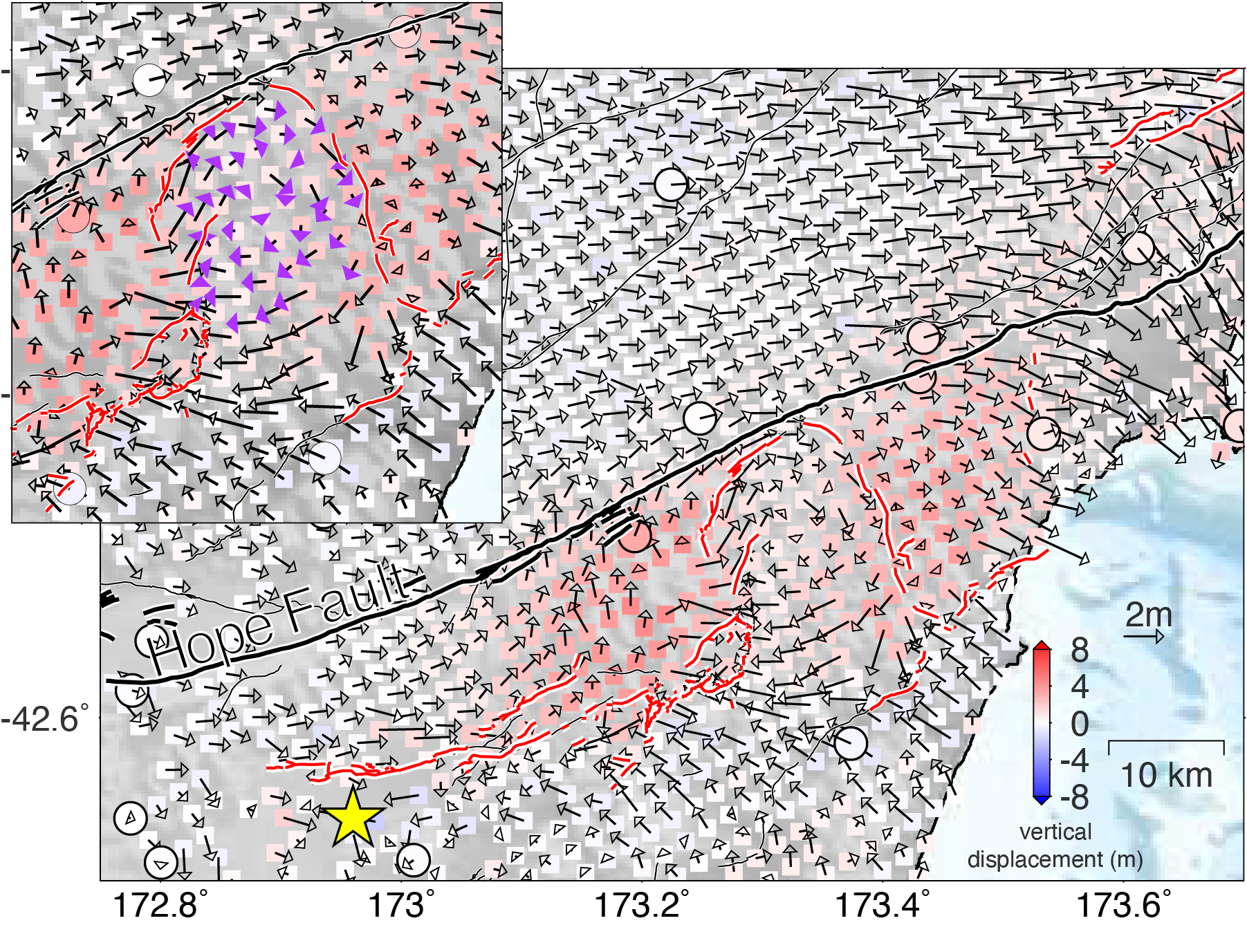
Three-dimensional (3D) coseismic displacement along the Hope fault, revealing a new rupture pattern as block rotation.
Hope断层附近三维同震形变场揭示的块体旋转破裂模式
Publications
Published in Frontiers in Earth Science, 2021
Download paper here
Recommended citation: Luo, H., Wang, T., Wei, S., Liao, M., and Gong, J. (2021). Deriving Centimeter-Level Coseismic Deformation and Fault Geometries of Small-To-Moderate Earthquakes From Time-Series Sentinel-1 SAR Images. Frontiers in Earth Science 9.
Published in Geophysical Research Letters, 2020
Download paper here
Recommended citation: Wang, T., Jiao, L., Tapponnier, P., Shi, X., & Wei, S. (2020). Space imaging geodesy reveals near circular, coseismic block rotation during the 2016 Mw 7.8 Kaikōura earthquake, New Zealand. Geophysical Research Letters, 47, e2020GL090206
Published in J. Geophys. Res., 2018
Download paper here
Recommended citation: Hu, X., Lu, Z. and Wang, T., (2018) Characterization of hydrogeological properties in Salt Lake Valley, Utah using InSAR, J. Geophys. Res, doi: 10.1029/2017JF004497
Published in BSSA, 2018
Download paper here
Recommended citation: Akoğlu, A, et al., Evidence for Tear Faulting from new Constraints of the October 23rd, 2011, Mw 7.1 Van (Turkey) Earthquake based on InSAR, GPS, Coastal Uplift and Field Observations BSSA
Published in EPSL, 2018
Download paper here
Recommended citation: Materna, K., et al., Source characteristics of the 2017 Mw 6.5 Moijabana, Botswana earthquake, a rare lower-crustal event within an ancient zone of weakness EPSL
Published in Science, 2018
Download paper here
Recommended citation: Wang, T.*, Q, Shi, M. Nikkhoo, S Wei*, S. Barbot, D., Dreger*, R. Bürgmann, M. Motagh & Qi-Fu C. (2018), The rise, collapse, and compaction of Mt. Mantap from the 3 September 2017, North Korean nuclear test, Science, doi: 10.1126/science.aar7230
Published in Geophys. J. Int, 2018
Download paper here
Recommended citation: Dutta, R., Jónsson S., Wang, T., and Vasyura-Bathke, H (2018), Bayesian Estimation of Source Parameters and Associated Coulomb Failure Stress Changes for the 2005 Fukuoka (Japan) Earthquake, Geophys. J. Int, doi: 10.1093/gji/ggx551
Published in Earth and Planetary Science Letters, 2018
Download paper here
Recommended citation: Wang, T., S. Wei, X. Shi, Q. Qiu, L. Li, D. Peng, R. J. Weldon, & S. Barbot (2018). The 2016 Kaikōura earthquake: Simultaneous rupture of the subduction interface and overlying faults. Earth and Planetary Science Letters, 482, 44-51.
Published in International Journal of Applied Earth Observation and Geoinformation, 2018
Download paper here
Recommended citation: Wang, T.*, DeGrandpre, K., Lu, Z., & Freymueller, J. T. (2018). Complex surface deformation of Akutan volcano, Alaska revealed from InSAR time series. International Journal of Applied Earth Observation and Geoinformation, 64, 171-180.
Published in Tectonophysics, 2017
Download paper here
Recommended citation: Wei, S., M. Chen, X. Wang, R. Graves, E. Lindsey, T. Wang, Ç. Karakaş, & D. Helmberger (2017), The 2015 Gorkha (Nepal) earthquake sequence: I. Source modeling and deterministic 3D ground shaking, Tectonophysics, doi:10.1016/j.tecto.2017.11.024.
Published in Journal of Volcanology and Geothermal Research', 2017
Download paper here
Recommended citation: DeGrandpre, K., Wang, T., Lu, Z., & Freymueller, J. T. (2017). Episodic inflation and complex surface deformation of Akutan volcano, Alaska revealed from GPS time-series. Journal of Volcanology and Geothermal Research, 347, 337-359.
Published in Remote Sensing of Environment, 2017
Download paper here
Recommended citation: Hu, X., Oommen, T., Lu, Z., Wang, T., & Kim, J., (2017). Consolidation settlement of Salt Lake County tailings impoundment revealed by time-series InSAR observations from multiple radar satellites. Remote Sensing of Environment, 202, 199-209.
Published in Geophys. Res. Lett., 2017
Download paper here
Recommended citation: Jiang, H., Feng, G., Wang, T.*, & Bürgmann, R. (2017). Toward full exploitation of coherent and incoherent information in Sentinel‐1 TOPS data for retrieving surface displacement: Application to the 2016 Kumamoto (Japan) earthquake. Geophys. Res. Lett., 44(4), 1758-1767
Published in Science, 2017
Download paper here
Recommended citation: Moore, J. D., Yu, H., Tang, C. H., Wang, T., Barbot, S., et al., (2017). Imaging the distribution of transient viscosity after the 2016 Mw 7.1 Kumamoto earthquake. Science, 356(6334), 163-167.
Published in Science Bulletin, 2017
Download paper here
Recommended citation: Shi, X., Wang, Y., Liu-Zeng, J., Weldon, R., Wei, S., Wang, T., & Sieh, K. (2017), How complex is the 2016 M w 7.8 Kaikoura earthquake, South Island, New Zealand? Science Bulletin
Published in Geophys. Res. Lett., 2017
Download paper here
Recommended citation: Schaefer, L. N., Wang, T., Escobar‐Wolf, R., Oommen, T., Lu, Z., Kim, J., Lundgren P. R. & Waite, G. P. (2017). Three‐dimensional displacements of a large volcano flank movement during the May 2010 eruptions at Pacaya Volcano, Guatemala. Geophys. Res. Lett., 44(1), 135-142.
Published in Remote Sensing of Environment, 2016
Download paper here
Recommended citation: Hu, X., Wang, T., Pierson, T. C., Lu, Z., Kim, J., & Cecere, T. H. (2016). Detecting seasonal landslide movement within the Cascade landslide complex (Washington) using time-series SAR imagery. Remote Sensing of Environment, 187, 49-61.
Published in Nature Communications, 2016
Download paper here
Recommended citation: Ruch, J.#*, Wang, T.#, Xu, W., Hensch, M., & Jónsson, S.* (2016). Oblique rift opening revealed by reoccurring magma injection in central Iceland. Nature Communications, 7. (joint-first-author).
Published in Geophys. Res. Lett., 2015
Download paper here
Recommended citation: Wang, T.*, Poland, M. P., & Lu, Z. (2015). Dome growth at Mount Cleveland, Aleutian Arc, quantified by time series TerraSAR‐X imagery. Geophys. Res. Lett., 42(24).
Published in Nature Geosci., 2015
Download paper here
Recommended citation: Avouac, J. P.*, Meng, L., Wei, S., Wang, T., & Ampuero, J. P. (2015). Lower edge of locked Main Himalayan Thrust unzipped by the 2015 Gorkha earthquake. Nature Geosci., 8(9), 708-711.
Published in Geophys. Res. Lett., 2015
Download paper here
Recommended citation: Wang, T.*, S. Wei, & S. Jónsson (2015), Coseismic displacements from SAR image offsets between different satellite sensors: Application to the 2001 Bhuj (India) earthquake, Geophys. Res. Lett., 42, 7022–7030.
Published in IEEE J. Sel. Top. Appl. Earth Observations Remote Sensing, 2015
Download paper here
Recommended citation: Wang, T.*, & Jónsson, S. (2015). Improved SAR amplitude image offset measurements for deriving three-dimensional coseismic displacements. IEEE J. Sel. Top. Appl. Earth Observations Remote Sensing, 8(7), 3271-3278.
Published in Seismological Research Letters, 2015
Download paper here
Recommended citation: Wei, S., Barbot, S., Graves, R., Lienkaemper, J. J., Wang, T., Hudnut, K., Fu, Y. & Helmberger, D. (2015). The 2014 M w 6.1 South Napa earthquake: A unilateral rupture with shallow asperity and rapid afterslip. Seismological Research Letters, 86(2A), 344-354.
Published in IEEE Geosci. Remote Sensing Lett., 2014
Download paper here
Recommended citation: Hu, X., Wang, T., and Liao, M. (2014). Measuring co-seismic displacements with point-like targets offset tracking, IEEE Geosci. Remote Sensing Lett. 11(1), 283 – 287
Published in Remote Sensing Letters, 2014
Download paper here
Recommended citation: Shi, X., Liao, M., Wang, T., Zhang, L., Shan, W., and Wang, C. (2014). Expressway deformation mapping using high-resolution TerraSAR-X images. Remote Sensing Letters, 5(2), 194-203.
Published in IEEE J. Sel. Top. Appl. Earth Observations Remote Sensing, 2014
Download paper here
Recommended citation: Wang, T.* and Jónsson S. (2014). Phase Ramp Reduction in Interseismic Interferograms using Pixel-Offsets, IEEE J. Sel. Top. Appl. Earth Observations Remote Sensing, 7(5), 1709-1718
Published in IEEE Geosci. Remote Sensing Lett., 2014
Download paper here
Recommended citation: Wang, T.*, Jónsson S. and Hanssen R. F (2014). Improved SAR Image Coregistration Using Pixel-Offset Series, IEEE Geosci. Remote Sensing Lett. 11(9), 1465 - 1469
Published in ISPRS journal of photogrammetry and remote sensing, 2013
Download paper here
Recommended citation: Liao, M., Jiang, H., Wang, Y., Wang, T., and Zhang, L. (2013). Improved topographic mapping through high-resolution SAR interferometry with atmospheric effect removal. ISPRS journal of photogrammetry and remote sensing, 80, 72-79.
Published in IEEE Geosci. Remote Sensing Lett., 2012
Download paper here
Recommended citation: Perissin, D., and Wang, T. (2012). Repeat-pass SAR interferometry with partially coherent targets. IEEE Trans. Geosci. Remote Sensing, 50(1), 271-280
Published in Science China Earth Sciences, 2012
Download paper here
Recommended citation: Liao, M., Tang, J., Wang, T., Balz, T., and Zhang, L. (2012). Landslide monitoring with high-resolution SAR data in the Three Gorges region. Science China Earth Sciences, 55(4), 590-601.
Published in IEEE J. Sel. Top. Appl. Earth Observations Remote Sensing, 2011
Download paper here
Recommended citation: Time-series InSAR applications over urban areas in China. IEEE J. Sel. Top. Appl. Earth Observations Remote Sensing, 4(1), 92-100. (2012 IEEE J-STARS Prize Paper Award)
Published in Science China Earth Sciences, 2011
Download paper here
Recommended citation: Wang, T.*, Perissin, D., Rocca, F., and Liao, M. (2011). Three Gorges Dam stability monitoring with time-series InSAR image analysis. Science China Earth Sciences, 54(5), 720-732.
Published in IEEE Geosci. Remote Sensing Lett., 2010
Download paper here
Recommended citation: Wang, T.*, Liao, M., and Perissin, D. (2010). InSAR coherence decomposition analysis. IEEE Geosci. Remote Sensing Lett., 7(1), 156-160.
Published in IEEE Trans. Geosci. Remote Sensing, 2007
Download paper here
Recommended citation: Liao, M., Wang, T., Lu, L., Zhou, W., and Li, D. (2007). Reconstruction of DEMs from ERS-1/2 tandem data in mountainous area facilitated by SRTM data. IEEE Trans. Geosci. Remote Sensing, 45(7), 2325-2335.