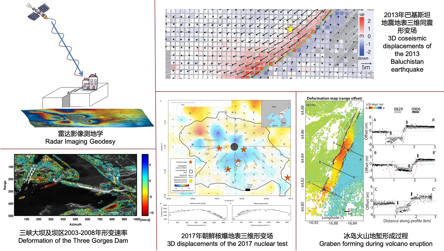
Synthetic Aperture Radar (SAR) is an active microwave remote-sensing sensor that emits electromagnetic waves and records the signals reflected back from the earth, forming radar images. Microwave signals are transmitted and received independent of sunlight and can penetrate through clouds, SAR imaging is thus not affected by illumination or meteorological conditions. The amplitude and phase information in SAR images can be processed to accurately measure the deformation of the earth’s surface in a range from a few millimeters to tens of meters, playing an indispensable role in basic research and application fields such as geophysics, environment monitoring and nature hazard. Our research involves digital signal processing, elasticity/fluid mechanics, physical model inversion, big data and artificial intelligence and etc.
合成孔径雷达(Synthetic Aperture Radar - SAR)是一种主动型微波遥感传感器,通过发射电磁波并记录地面反射回卫星的微波信号得到雷达影像。微波信号的发射和接收不依赖阳光并可以穿透云层,所以SAR成像不受光照和气象条件的约束。利用SAR影像的强度和相位信息可以对地表几毫米到数十米的形变进行精确量测,在地球物理、环境监测、防灾减灾等基础研究和应用领域均起到不可或缺的作用。我们的研究涉及数字信号处理、弹性/流体力学、物理模型反演、大数据分析和人工智能等多个学科。
Selected publications
Ziming Liu, & Teng Wang*, High-Resolution Interseismic Strain Mapping From InSAR Phase-Gradient Stacking: Application to the North Anatolian Fault With Implications for the Non-Uniform Strain Distribution Related to Coseismic Slip Distribution. Geophysical Research Letters, 2023, 50(15), e2023GL104168.
Heng Luo, Teng Wang*, Shengji Wei, Systematic comparison of InSAR and seismic source models for moderate-size earthquakes in western China: Implication to the seismogenic capacity of the shallow crust. Journal of Geophysical Research: Solid Earth, 2022, 127, e2022JB024794.
Lv Fu, Qi Zhang, Teng Wang*, Weile Li, Qiang Xu, Daqing Ge, Detecting slow-moving landslides using InSAR phase-gradient stacking and deep-learning network. Frontiers in Environmental Science. 2022, 10.963322.
Zhipeng Wu, Teng Wang*, Yingjie Wang, Robert Wang, Daqing Ge, Deep learning for the detection and phase unwrapping of mining-induced deformation in large-scale interferograms, IEEE Transactions on Geoscience and Remote Sensing, 2022, vol. 60, pp. 1-18.
Teng Wang*, Liqing Jiao, Paul Tapponnier, Xuhua Shi, and Shengji Wei, Space Imaging Geodesy Reveals Near Circular, Coseismic Block Rotation During the 2016 Mw 7.8 Kaikōura Earthquake, New Zealand, Geophysical Research Letters, 2020, 47(22), e2020GL090206
Teng Wang*, Qibin Shi, Mehdi Nikkhoo, Shengji Wei*, Sylvain Barbot, Douglas S Dreger*, Roland Burgmann, Mahdi Motagh, Qifu Chen, The rise, collapse, and compaction of Mt. Mantap from the 3 September 2017 North Korean nuclear test, Science, 2018, 361(6398), 166-170.
Teng Wang, Shengji Wei*, Xuhua Shi, Qiang Qiu, Linlin Li, Dongju Peng, Ray J. Weldon, Sylvain Barbot, The 2016 Kaikōura earthquake: Simultaneous rupture of the subduction interface and overlying faults, Earth and Planetary Science Letters, 2018, 482:44-51.
Joel Ruch#*, Teng Wang*, Wenbin Xu, Martin Hensch, Sigurjon Jonsson*, Oblique rift opening revealed by reoccurring magma injection in central Iceland, Nature Communications, 2016, 7:12352.
Projects
国家自然科学基金委员会,国家自然科学基金面上项目:雷达影像大地测量揭示的滑坡活动性在地震周期中的演化规律 | Landslide Activities during Earthquake Cycle Revealed by Radar Imaging Geodesy(42374019),2024/01-2027/12,51万元,PI
国家科技部,重点研发项目:广域重大地质灾害隐患综合遥感识别技术研发,课题3:时空信息协同的崩滑隐患关联要素智能识别技术研发-子课题:广域InSAR形变集中区智能识别及动态监测技术研究(2021YFC3000403),2021/12-2025/05, 80万元,Co-I
国家自然科学基金委员会,创新群体项目:断裂带物理学,2021/01-2025/12,120万元,Co-I
中国自然资源航空物探遥感中心,滑坡变形InSAR相位异常智能探测方法研究,2021/9-2022/5,70万元,PI
中国科学院空天信息创新研究院,Sentinel-1广域InSAR分布式数据处理模块研发,2020/12-2021/12,18万元,PI
国家自然科学基金委员会,地震联合基金重点支持项目:川滇地区构造应力场与强震活动关系研究 | Tectonic Stress Field in the Sichuan-Yunnan Region and its Relationship with Large Earthquakes(U1939202),2020/01-2023/12,70万元,Co-I
国家自然科学基金委员会,国家自然科学基金面上项目:三维同震形变场揭示的地表破裂模式与地形塑造作用 | Three-dimensional coseismic displacement fields reveal surface rupture patterns and topography evolution(41974017),2020/01-2023/12,64万元,PI
国家科技部,重点研发项目:基于地壳形变场、温度场、流体场耦合的地震监测技术研究,课题4:地壳形变场、温度场、流体场耦合断层力学模型与协同机制研究(2019YFC1509204),2020/01-2023/01, 45万元,Co-I